RTC proposes adding new lanes to I-5 north of the Columbia River
The current I-5 corridor is being squeezed as Vancouver develops its waterfront with condos, restaurants, shops, a hotel and much more. The amount of land for the transportation corridor currently owned by the Washington State Department of Transportation (WSDOT) varies in width from an estimated 200 feet to 375 feet near SR-500 at the north end of the “bridge influence area.” What is the best use of the available transportation real estate?
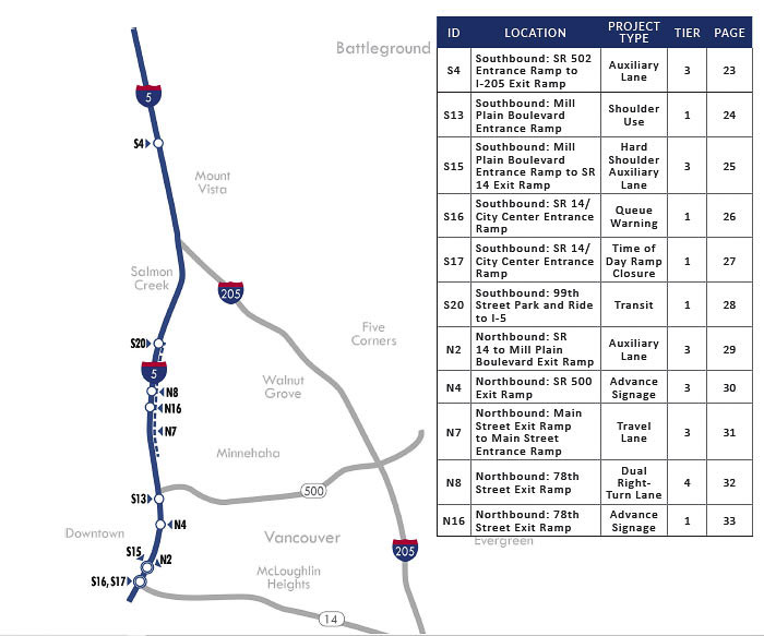
The Southwest Washington Regional Transportation Council (RTC) has added new lanes to I-5 north of the Columbia River in its 2040 Regional Transportation Plan (RTP). Most of these are “auxiliary lanes” and in some locations the RTC proposes to have vehicles drive on existing shoulders. The RTC hopes to add vehicle capacity to reduce current and future levels of traffic congestion.
The Interstate Bridge Replacement Program (IBR) team has announced numerous options being considered for the project. The IBR team indicates there is “substantial demand” for high capacity transit. Recently two new options were added for consideration, 11 total plus a “no build” option required by the federal government.
The majority of the options have the high capacity transit traveling in a dedicated lane along the west side of I-5 in Vancouver. The high capacity transit options are either a bus rapid transit (BRT) line or an extension of the TriMet MAX light rail line. There is one hybrid option that extends light rail to Hayden Island and connects to a BRT line.
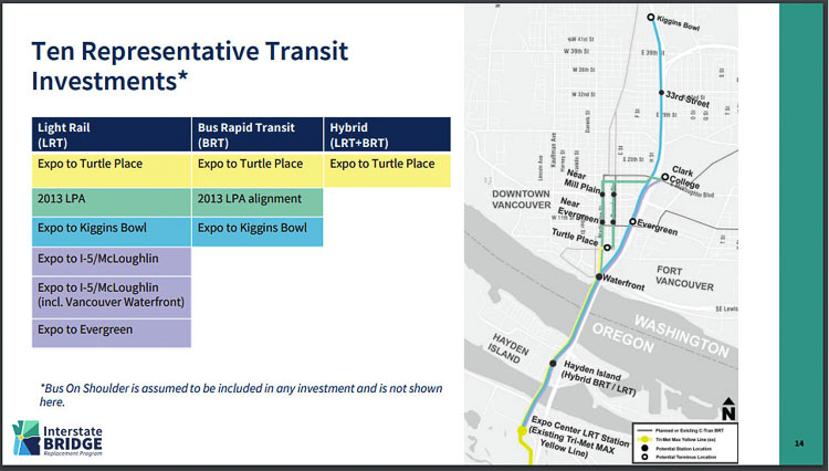
Three of the options extend BRT lines to the Portland Expo Center. One extends The Vine from downtown Vancouver at the Turtle Place transit center. Another connects Clark College at McLoughlin Blvd. on the 2013 proposed alignment to Expo. Finally, the third option runs from Kiggins Bowl (on the northwest side of where SR-500 merges with the interstate) on a dedicated I-5 lane to Expo.
All the BRT options would need a normal 12-foot-wide freeway lane for real estate on both the bridge and on I-5. One option is to choose to separate the “dedicated lane” from the rest of traffic by putting up a jersey barrier, which would add another two feet.
But when it comes to extending MAX light rail down I-5, that creates an entirely different series of discussions. How wide are the current light rail tracks and how much real estate does that require?
On a city street, like running down Interstate Avenue or on the I-84 MAX line next to the freeway, there is roughly 35 to 40 feet required when two sets of tracks are put down, side by side. That’s the equivalent of three 12-foot vehicle lanes. Real estate for cars and trucks is already at a premium on I-5 according to the IBR team, especially within the five-mile bridge influence area the IBR has under its authority.
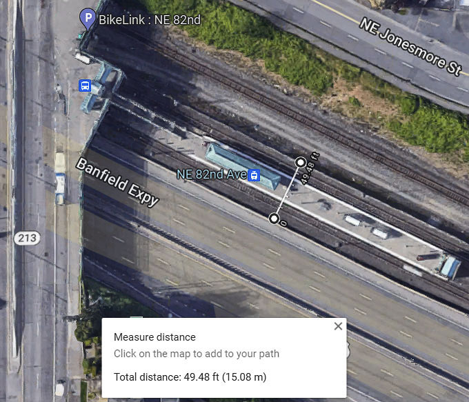
The IBR team was asked how wide is the real estate currently owned by WSDOT on the Vancouver side of the river. They pointed to a “maps online” tool provided by Clark County.
Using the measuring tool, the amount of land consumed by light rail varies. There appears to be about 36 feet of width for tracks on the MAX Red line running down the middle of I-205 coming from the Portland airport. Yet the total protected land between the freeway lanes appears to be about 80 feet.
Next to I-84, the 82nd Ave. MAX transit station appears to be about 50 feet wide. The Parkrose transit center shows about 70 feet of land used for light rail. But overall, it appears the side-by-side tracks remove 36 feet of land that could be used for three lanes of traffic.
Each of those lanes could handle 1,800 to 2,000 vehicles per hour to reduce traffic congestion. That’s up to 6,000 vehicles an hour, reducing traffic congestion.
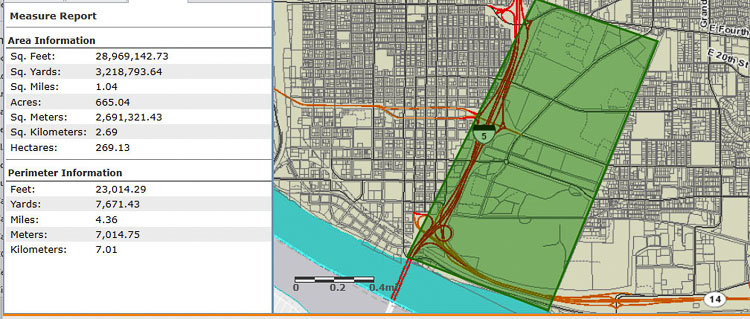
IBR Administrator Greg Johnson has said a bridge with three through lanes is the only option “because there are only three lanes north and three lanes south of the bridge.” Is there enough real estate for Johnson’s team to build more than three through lanes? His team will have control of over five miles, the “bridge influence area.” The 2.5 miles north of the border runs up to the Fourth Plain interchange with I-5.
The online tool shows there is currently one square mile of sparsely developed land on the east side of I-5. Some of that land is owned by Fort Vancouver. A great deal of it appears to be owned by Clark College. But the potential is there for Johnson’s team to access a small slice of that land in order to add vehicle lanes in order to help reduce traffic congestion and save people time in their travels.
On the Oregon side, there is plenty of land available in the Delta Park area to add lanes and vehicle capacity. The southern end of the IBR’s “bridge influence area” in Oregon is the Columbia Blvd. interchange.
Yet, in spite of Johnson’s claim, the Regional Transportation Plan (RTP) for 2040 calls for the addition of one new lane in each direction to I-5 between SR-14 and Mill Plain Blvd. One lane in the northbound direction and one in the southbound direction. The plan calls for these to be “auxiliary lanes,” but there appears to be room for about 10 or more lanes in the area where the bridge lands in Washington.
In fact a width of 200 feet could allow for 16, 12-foot lanes to be squeezed in at the narrowest point in the I-5 corridor north of the border. Yes, there would need to be ramps and lanes for SR-14 to merge onto I-5.
Practically speaking, 10-12 foot shoulders are needed for safety. That would therefore allow for 12 lanes, six in each direction on I-5. There would need to be sound walls to keep the noise away especially on the west, downtown side of the freeway.
One option the IBR team is studying is a double deck bridge.The top and bottom structures could proceed north of Mill Plain, perhaps touching down either north or south of Fourth Plain. The terrain rises by over 100 feet in the area. That would essentially “double” the capacity of existing WSDOT real estate, to support a bridge structure and freeway to handle vehicles.
Transportation architect Kevin Peterson has argued for a “collector-distributor” where “local” traffic merging on and off I-5 would use the lower bridge structure. The higher speed through traffic would use the upper deck and travel at normal freeway speeds.
The 2040 RTP also calls for extending an auxiliary lane for a total of four lanes in each direction north of Main Street. It calls for shoulder use on southbound I-5 from SR-500 Why wouldn’t the IBR include widening I-5 here, instead of people needing to drive on the shoulder as the RTC plan calls for?
Should the IBR team take 35 to 40 feet of WSDOT real estate to permanently remove land for future freeway lanes?
Sen. Lynda Wilson asked for details at the last Bi-state Bridge Committee meeting. “Once you lay down the tracks, that’s permanent,” Wilson said. She expressed concerns about people being forced to live along the light rail corridor to access that form of transit. Whereas the BRT and even the express bus service is very flexible, she noted.
Clark County Today asked the IBR the following, with responses in bold.
What is the width of land required to build a bus rapid transit lane in each direction on I-5 from the river to Fourth Plain?
Specifics such as property needs are design-level details that have not yet been determined.
How many people can “high-capacity transit” take off the I-5 freeway?
Long-range models which include land use and various other impacts will also help determine potential transportation mode shift and are still underway.
Will a “multi-modal” solution “handle all the current and future needs through this corridor”?
A multimodal solution that provides choices and improves options for all modes of travel — including high-capacity transit and active transportation — is critical for addressing congestion and advancing more efficient movement of people and goods across the Columbia River.
Numerous details are expected to be revealed on April 21 by Johnson and his IBR team. One of those “choices” will be a recommended form of high capacity transit. Another will be the design of the bridge, including either one double stack structure or two side-by-side bridges. The total number of lanes and the interchanges recommended for Hayden Island will be at the top of people’s concerns.
If the IBR proposes high capacity transit in a “dedicated lane,” that will keep cars and trucks from using that on this congested transportation corridor.
The IBR community surveys indicate people’s top priority is reducing traffic congestion and saving time. What will they deliver?

Also read:
New law protects docs who prescribe ivermectin, hydroxychloroquine