

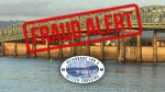
The Executive Summary seems to indicate after spending $7.5 billion, a price tag that is expected to increase next summer, there will be only 5,000 fewer vehicles on I-5 than if nothing was done
John Ley
for Clark County Today
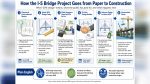
The Interstate Bridge Replacement Program (IBR) released its Draft Supplemental Environmental Impact Statement (DSEIS) today (Sept. 20). It is “supplemental” because there is a previously approved EIS that the IBR team is basing the proposal on. Citizens can review the Draft SEIS, the executive summary and the technical reports that informed it. The documents are now published, and the 60-day public comment period is open Sept. 20 through Nov. 18, 2024.
The $7.5 billion project includes a “no build” option for comparison with what the various “impacts” are for the various options presented. Most of the charts don’t show “current” numbers for comparison of today versus the 2045 traffic, travel times, and vehicle numbers, etc.
The Executive Summary seems to indicate after spending $7.5 billion, a price tag that is expected to increase next summer, there will be only 5,000 fewer vehicles on I-5 than if nothing was done.
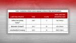
Currently, there are about 10 and one half hours of traffic congestion on the I-5 corridor. After construction with only one auxiliary lane, the DSEIS reports there will be 13.75 hours of congestion, a 31 percent increase. But instead, the report only compares the “no-build” option in 2045 to show a decrease.
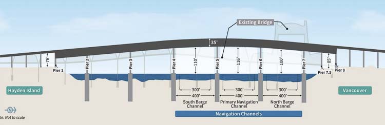
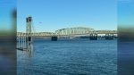
There is a single deck option (much wider); a double deck option, and an option with a movable span, like the current bridge. There is also an option to move the location of the new structure a little farther west, impacting more homes and businesses.
IBR Administrator Greg Johnson wants people to review the roughly 10,000 pages and offer input to the program. “If you like it, comment. If you hate it, comment,” he said.
There are two major controversial components for Clark County citizens – tolling and light rail. Johnson told reporters the financial plan includes tolls which would pay back borrowed funds ranging from $1.1 billion to $1.6 billion. The amount of the tolls will be determined by a subcommittee of the two states transportation commissions. Clark County’s Roy Jennings is one of those members.
The other critical component to many people in the path of the project, is how many houses and businesses will be impacted. There will be between 43 and 76 residential units displaced. One design option (Modified Locally Preferred Alternative with I-5 mainline westward shift) would result in the loss of 76 residential units, while the other design options would displace 43 units.
Between 36 and 39 businesses would be displaced. One design option (Modified LPA with I-5 mainline westward shift) would result in the loss of 39 businesses, while the other design options would displace 36 businesses. The Waterfront Park-and-Ride Site #3 Option would result in one additional business displacement, the IBR reports.
Many of these residents and businesses are concerned about the government simply “taking” their property. The IBR reports “acquisition of property would typically occur through negotiated purchase or eminent domain.” They expect the “Permanent Acquisitions Area Acquired” to be 36.5 acres.
Ray Mabey, assistant program administrator, told reporters that they expect a 35 percent increase in total “person throughput” compared to today. This would include people in privately owned vehicles (POV), freight haulers, transit riders, and “active transportation” riding bikes or walking.
The Modified LPA is allocating 54 percent of the bridge surface area to transit, bikes, and pedestrians. Only 46 percent is for POVs and freight haulers who will be paying all the tolls.
Mabey shared they expect a 3 percent reduction in vehicles on I-5, when compared to the “no build” alternative. This equates to 5,000 fewer vehicles in 2045. But more importantly, the IBR is projecting the current 143,000 vehicles will increase to 175,000, a 22 percent increase.
In the failed Columbia River Crossing, it was predicted that 35,000 vehicles would divert to I-205 if only I-5 were tolled. One wonders what the numbers are for I-205 traffic in the current proposal.
The timeline for construction indicates the entire project could take from 9 to 15 years.
There is a 62-page Executive Summary, a table of contents, plus four chapters, appendices, and technical reports sections. “The text of the Purpose and Need has not been edited from its original wording, except for references to the name of the Program.”
Reducing traffic congestion
The top concern citizens have expressed that they want addressed is reducing traffic congestion and saving time in their travels. The IBR reports: In 2005, 280,000 vehicle trips crossed the Columbia River daily (northbound and southbound) in the PortlandVancouver metropolitan region, of which 134,000 used the Interstate Bridge. By 2019, the total number of vehicle trips that crossed the Columbia River had increased to 313,000 per day, of which 143,400 used the Interstate Bridge. Vehicle trips include those made in single-occupancy vehicles, high-occupancy vehicles, trucks, and transit vehicles (buses).
The program notes that traffic demand over the Interstate Bridge is expected to increase by 25 percent by 2045. Vehicle-hours of delay on truck routes in the Portland-Vancouver area are projected to increase by more than 90% over the next 20 years. Growing demand and congestion will result in increasing delay, costs, and uncertainty for all businesses that rely on this corridor for freight movement.
Yet, the current proposal adds no new through lanes to the bridge, and the locally preferred alternative (LPA) has only a single auxiliary lane for merging and weaving. Furthermore, 54 percent of the bridge surface is for transit, bikes and pedestrians. Only 46 percent is allocated for private vehicles and freight haulers.
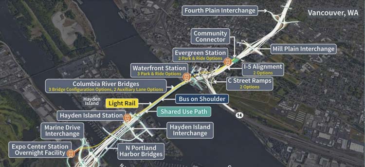
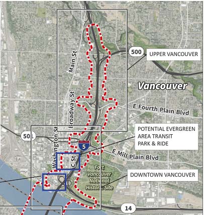
There is an option that shifts the I-5 mainline up to 40 feet westward in downtown Vancouver between the SR 14 interchange and Mill Plain Boulevard interchange. A different option that eliminates the existing C Street ramps in downtown Vancouver is being evaluated.
Clark County Today will continue to research the roughly 10,000-page Draft Supplemental Environmental Impact Statement and continue to provide coverage.
Also read:
- Opinion: IBR program’s $13-17 billion fraud and mismanagement, perpetuated by Vancouver Mayor Anne McEnerny-Ogle and Oregon Gov. Tina Kotek
 Gary Clark argues IBR hid a $17B cost estimate from lawmakers while spending up to $280M with no public benefit.
 - Opinion: The IBR shell game for TriMet at Ruby Junction
 IBR allocates $320M for a TriMet maintenance facility 20 miles from the actual bridge project.
 - Washington and Oregon transportation commissions discuss tolling options
 I-5 tolls could range from $1.55 to $4.70 depending on the plan, with final rates set in late 2027.
 - Letter: ‘That is why the process matters’
 The I-5 river bridge package is at roughly 30% design, meaning final construction drawings and final price are not yet set.
 - Letter: Forty years of Democrat governors’ judicial appointments
 Tom Schenk argues 150 Democrat-appointed judges shape Washington courts with no impartial check.