

Some areas of the county experience hotter temperatures and that can cause some communities and families to be more impacted by excessive heat and can worsen health inequities
VANCOUVER – The results of a one-day heat mapping project conducted in Clark County last summer show that heat is not distributed evenly across the county. Some areas of the county experience hotter temperatures and that can cause some communities and families to be more impacted by excessive heat and can worsen health inequities.
“People who live in historically disinvested neighborhoods, who have limited access to resources like air conditioning and green space, and those with other health issues are all at greater risk for impacts from extreme heat,” said Amy Koski, built environment coordinator with Clark County Public Health.
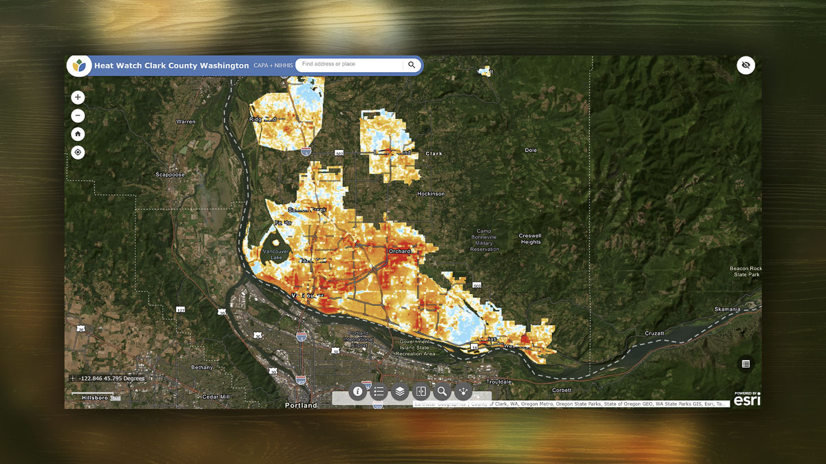
The unequal distribution of heat was reflected in data collected on July 12, 2024, during the Heat Watch event organized by Clark County Public Health with the support of more than 50 volunteers and technical assistance from CAPA Strategies. Volunteers attached special equipment to their cars, drove 17 planned routes across the county and collected more than 102,000 temperature readings in the morning, afternoon and evening.
The data shows that areas with more buildings and development tend to be hotter during the afternoon, and during the evening there is nearly a 10-degree difference in temperature, depending on location. Buildings, roads, and other paved surfaces with a lack of shade hold on to more heat than natural landscapes or areas with more trees.
According to data collected during the Heat Watch event:
- The hottest areas in the afternoon included most of the Vancouver area, including downtown, Orchards, Fourth Plain and Fruit Valley. Washougal, downtown Camas and downtown Battle Ground also had areas with higher temperatures.
- Cooler places during the afternoon included west and central Camas, and places with more green and natural spaces, like the Burnt Bridge Creek Trail area in Vancouver.
- Hotter areas in the evening included Washougal, central and east Vancouver (especially Ogden, Bennington and Fisher’s Landing East neighborhoods).
- Cooler places in the evening included Ridgefield, La Center, northwestern Vancouver (Mount Vista, Felida and Lake Shore neighborhoods) and northwest Battle Ground (Cherry Grove).
Heat maps on the Public Health website show the variation in temperatures across the county throughout the day. Heat maps can be used to inform the development and implementation of a range of cooling activities through land use, built environment, transportation, and community infrastructure policies and plans. The data can also be used to support grant applications, the development of extreme heat preparedness and response plans, and long-term climate action strategies.
Public Health staff shared these findings with the Clark County Board of Health during a meeting Wednesday, June 25.
Health impacts
Extreme heat is the deadliest weather-related hazard in the United States. Washington summers are getting longer and hotter, and extreme heat waves are becoming more frequent. When temperatures rise, the number of emergency department visits for heat-related illness in Clark County increases. In addition to heat-related illnesses, heat can cause heart and breathing problems and pregnancy complications, as well as impact mental health.
But the impacts of extreme heat are not evenly distributed. Some groups are more at risk for serious effects from heat, including:
- Infants and children
- Pregnant people
- Older adults
- People with existing health conditions or who take certain medications
- People living unsheltered or unhoused
- People living in urban heat islands or without access to air conditioning
- People who exercise outdoors
- Outdoor workers
Clark County residents can prepare for hot weather by signing up for public alerts and monitoring weather and Heat Risk forecasts during warm weather months. When temperatures rise, residents should take steps to prevent heat-related illnesses and check on neighbors, especially those most at-risk for heat-related illnesses.
Visit the Public Health website to learn more about the Heat Watch event, review the summary report and watch a video about the event.
Information provided by Clark Co. WA Communications.
Also read:
- Letter: ‘That is why the process matters’
 The I-5 river bridge package is at roughly 30% design, meaning final construction drawings and final price are not yet set.
 - Letter: Forty years of Democrat governors’ judicial appointments
 Tom Schenk argues 150 Democrat-appointed judges shape Washington courts with no impartial check.
 - Work begins this month to improve intersection at Northeast 182nd Street and Risto Road
 A new single-lane roundabout replaces the existing intersection at Northeast 182nd Avenue and Risto Road starting June 22.
 - Community attends ribbon-cutting event to celebrate new Curtin Creek Community Park
 Curtin Creek Community Park opened with a ribbon-cutting, decades after the land was first purchased in 1999.
 - It’s an early morning for those who participate in the annual Junior Market in Vancouver
 175 booths and 300 small businesses, all run by teens and children, filled Esther Short Park for Lemonade Day Junior Market.
 - Clark County Sheriff’s Office investigating deadly stabbing in Battle Ground
 A man died and a woman was hospitalized after a stabbing near NE 117th Ave and NE 244th St in Battle Ground.
 - Charter Review Commission members grow increasingly frustrated with overreach by county executives
 Commissioners Donnelly, Gasque, and LaBrant accused county staff and Auditor Kimsey of tilting the charter amendment process.