

Over half the replacement bridge will be dedicated to transit and active transportation. But will people use it instead of their cars?
John Ley
for Clark County Today
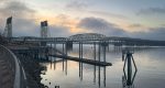
One of the hundreds of issues area residents will want to offer “comment” on regarding the proposed Interstate Bridge replacement project is the active transportation facilities. On Friday, the Interstate Bridge Replacement Program (IBR) opened a 60-day public comment period as it released the roughly 10,000-page Draft Supplemental Environmental Impact Statement (DSEIS). The documents are now published, and the 60-day public comment period is open Sept. 20 through Nov. 18, 2024.
The current proposed project will spend at least $7.5 billion, including $2 billion for transit and active transportation facilities on the bridge. These facilities include transit stops at both the Vancouver waterfront and on Hayden Island. The IBR proposal has allocated 54 percent of the surface of the bridge for transit, bikes, and pedestrians, and only 46 percent for vehicles and freight haulers.
The program revealed earlier in the process that there are 370 active transportation trips a day, compared to over 165,000 general purpose vehicle trips. The DSEIS states “an estimated 410 bicyclists and pedestrians, on average, make trips across the bridge daily.”
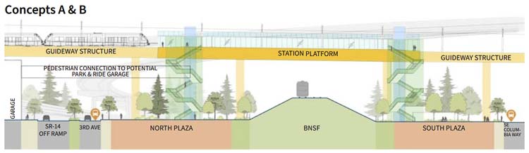
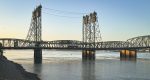
One issue for Vancouver citizens has been the waterfront transit stop. The MAX light rail station and bike/pedestrian facilities would be above an active BNSF rail line. The program had previously told the 16 members of the Bi-State Legislative Committee that it could be up to 90 feet above the ground, which brought a lot of pushback.
An additional consideration has been the need for the project to seize the Hurley building, which is just five years old. This is the site for the proposed waterfront transit station.
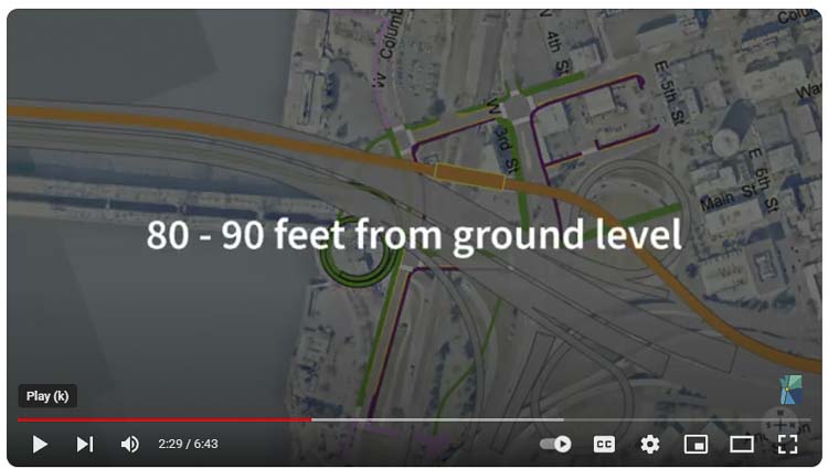
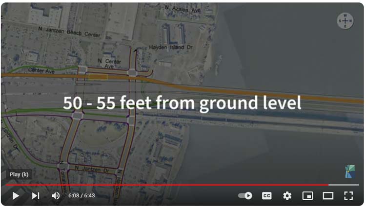
As part of their communication regarding the DSEIS, the IBR has revealed that the Vancouver waterfront transit station and active transportation facility will be 80 to 90 feet above the ground. A video seems to indicate there will be a double spiral ramp needed to get bikes and pedestrians down to ground level. They also reveal that the Hayden Island facility will be 50 to 55 feet above the ground.
“We are doing some unique things that are different than you would see on a mega project anywhere else,” said Greg Johnson, IBR administrator earlier this summer. “No. 1, you don’t see a lot of bike, walk and roll facilities on interstate highways. And this one, we are making it an attractive part of what we are doing to try and get folks out of those single-occupancy vehicle trips.”
In June, Sen. Lynda Wilson told Johnson they should be focusing on the needs of cars and freight haulers. “I have a concern that we’re paying more attention to multimodal transportation,” she said.
There appears to be no breakdown of cost data for the various components of the transit piece of the IBR. What are the details of the Vancouver waterfront transit station? What are the costs of each of those proposed details? There is a possible Park ‘n Ride facility at that location. How many vehicles will use it for transit, and what is the cost?
If citizens are to provide input on the tens of thousands of details contained within the DSEIS, shouldn’t they know the costs in addition to why any particular component is “needed” and included in the project?
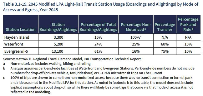
A logical question is how many transit riders does the IBR expect to use the Vancouver waterfront transit station? The IBR predicts 3,300 boardings or about 1,650 people a day. How many bikers and pedestrians will use a station that high above the ground?
With the Evergreen transit center (end of the line) just about 2,500 feet away to the north, why wouldn’t those active transportation people stay on the light rail until they reach ground level? This would be especially true during wind and rain experienced during the late fall, winter, and spring weather events.
Similar questions are appropriate for Hayden Island. How many people is the IBR program expecting to use the facility on the island?
The DSEIS has information on transit ridership in Chapter 3. But much of it is from 2019 rather than more current data. Earlier this year, the Regional Transportation Council (RTC) Board was briefed that there is a “new normal” both locally and nationally, with reduced transit ridership, more people working from home, and people using their privately owned vehicles.
There are even greater questions regarding the “need” for any high capacity transit on the project. Presently, there is so little demand for cross river transit, that only C-TRAN offers bus service. The decline in ridership due to pandemic lockdowns caused the bus company to reduce their “Express” bus service from seven separate lines down to just three bus lines. And that is for both the I-5 and I-205 corridors.
In 2023, C-TRAN reported just 525 boarding a day on their I–5 express buses. These are routes 105 and 105X. They reported 295 boardings on their express route 164 which uses I-205.
The 105X route is the fastest, avoiding a stop in downtown Vancouver. They currently offer five buses in the morning and five in the evening. The non-express 105 route service includes a stop in downtown and runs about every 45 minutes, depending on the time of day. In the morning it can be every 15 or 20 minutes, and hourly during the rest of the day.
In the past, when TriMet added MAX light rail service, it was simply replacing existing bus service with more expensive light rail service. Will C-TRAN further cut back bus service over the river?
The DSEIS states the following about the Waterfront Station.
As described in Chapter 2, there are three site options for a new park and ride facility near the proposed Waterfront Station. Two of these sites (Sites 2 and 3) would require the acquisition of additional property beyond that needed for the highway and transit facilities. Site 2 would require full acquisition of one commercial parcel and no displacements. Site 3 would require full acquisition of four commercial parcels and displacement of one business. Site 1 would not require any acquisitions or displacements. Property impacts associated with the Waterfront Station park-and-ride options are shown in Table 3.3-4 and are in addition to the impacts identified in Table 3.3-3.
Additional perspective is that C-TRAN officials told the Federal Transit Administration (FTA) they expected 5,000 to 6,000 daily boardings on their Vine Bus Rapid Transit service on opening day. They predicted growth to 8,000 to 9,000 boardings. In 2023, ridership was down to 3,232 boardings on Fourth Plain in 2023. These ridership projections seem overly “optimistic” in the extreme.
Randall O’Toole has been examining transit for decades and is known as the “Anti Planner.” He talks about “strategic misrepresentation” as a form of lying on light rail and these mega projects. He notes they over project transit ridership and under estimate costs in a recent column entitled, “Lie Rail Supporters Keep On Lying.’’
Citizens can make input and public comments here (item 4 on the page).
Also read:
- Opinion: The many reminders not to speed
 Doug Dahl examines the many technological and policy-based reminders aimed at reducing speeding and explains why most drivers still choose not to use them voluntarily.
 - Rep. John Ley’s new bill calls for an independent audit of Interstate 5 Bridge Replacement Project
 Rep. John Ley introduced legislation requiring an independent audit of the Interstate 5 Bridge Replacement Project to review costs, management, and oversight.
 - Opinion: IBR’s evasive, misleading and dishonest excuses for higher cost
 Joe Cortright argues the Interstate Bridge Replacement Program has withheld detailed cost estimates while offering contradictory explanations for rising costs tied to the I-5 Bridge project.
 - Rep. David Stuebe sponsors bill to strengthen enforcement of auto insurance laws and protect Washington drivers
 Rep. David Stuebe has introduced HB 2308, a bill aimed at strengthening enforcement of Washington’s auto insurance laws and increasing accountability for repeat uninsured drivers.
 - Letter: Interstate Bridge Replacement’s Park & Ride insanity
 Bob Ortblad criticizes the Interstate Bridge Replacement Program’s proposed Park & Ride garages, arguing the costs are excessive and unlikely to receive federal funding.
I must have a vision problem. I just don’t see 450 bike riders going across the bridge every day. Nor any more foot traffic than there is now.
If the argument is about putting the Portland choo-choo line on the bridge then I can tell you what transit station you can park that.
We don’t need tolls! People are already struggling! Use the weed money, the lottery money, the gas tax, the high property taxes, etc. figure out where all that money is going and use it wisely! We need improved highways, not more idiotic changes that cause more traffic issues! We are not all going to ride bikes or get on unsafe transit! Make common sense decisions! That would be refreshing in this area!! Better freeways and less traffic issues will help draw businesses and help grow our city!! Please use this opportunity and our tax dollars to help us grow, not hold us back!!! 🙏🙏🙏🤔🙄👀🧐
It’s call lite rail for a reason their is no capacity to move people. The little choo choo that couldn’t is always empty and going at a snails pace,
i just don’t think it is right for are Government to force us to have the light rail to come in to Vancouver we the people has turned down the light rail over and over. i believe our politicians are supposed to work for us not tell us what we should have.
It wasn’t right for them to force light rail on the people Portland that kept voting it and its extensions down, beginning in the 80s.
The glen jackson bridge (205)was designed for light rail. Why don’t they use it??
As usual, the cabal of contractors and politicians and unions that support “public transit” via “light rail” are pushing their usual impractical and overly expensive ideas. A transit station perched 9 or 10 stories above ground (with a circular ramp, no less) is simply not going to be used. (There will also need to be expensive to maintain elevators.) Note, I used to work on the 7th floor of a 10 story office building. Typically we would walk up one floor or down two floors — everything else we used one of 8 elevators that served the building. In my 21 years there, I don’t think I ever walked all the way down more than once or twice and I know I never walked up to my floor from the ground floor.
Public transit on the IBR can easily be served by “Bus Rapid Transit” — which should have most busses enter the freeway and go directly to a central Tri-Met station to access multiple Tri-Met lines. The extension line proposed is a particularly slow route, operating over city streets, with stop lights and (auto) traffic to contend with. Even an “express” train (that skips stops) could not provide much faster service, since all trains on this route are speed limited by ground traffic. With the current configuration of Tri-Met, there is no possible way that Clark County would ever receive efficient and fast service over their trolly lines. Thus ridership is likely to be far, far lower than estimated. (I note that national averages of proposed projects compared to the completed projects have averaged double the cost to build and generated half the passenger traffic estimated before construction. I suspect that the Tri-Met extension will have far less than half the projected traffic as it is a particularly undesirable service line.)
For starters, the exit ramp to SR-14 Eastbound will be Vancouver’s version of Mr. Toad’s Wild Ride, as it has to fit under (former) Mayor Pollard’s”Land Bridge”, which SR-14 has to land in front of and underneath it.
What local people need to realize is how much local money is going to be required on this Loot Rail fiasco from the City and C-TRAN, which is the same group of people wearing different hats. If Proposition 4 is somehow passed, and the property tax levy lid is removed, the new tax increases on home owners will never stop. You will never pay enough, so everything your home is worth is your “fair share”. Keep in mind that new taxes on businesses are paid by their customers, you that is.
And that’s before we get to the big 10 year, $100 Million “bridge shelter” for “the homeless”. If you think more tax money will clear out the crew around Mill Plain/I-205 and elsewhere, think again. That’s another issue you will never pay enough money for.
Add in all of the discussion going on from the Harris campaign about transportation spending and things get really scary.
Here’s hoping that enough thinking people vote Prop 4 and a few more measures down very soon.
Clark County voters REJECTED the proposition to extend TriMet MAX light into Vancouver over the I-5 bridge. There are so many attacks in the trains, and stations of the MAX light rail system, stabbings, shootings, elderly being hit with a baseball bat, 3-year old pushed from platform onto the tracks, 2-year old poked with needle, sexual assaults, thefts and more. This video of a woman being repeatedly thrown down several flights of stairs at a light rail station in Seattle midday is especially concerning.
The main focus of the planners and powers that be is to continue their social engineering making it harder to own and drive vehicles, forcing us to take some form of mass transit, walking or biking. They KNOW that for many of us, those are not viable options.
What is the overall plan for light rail and why is it not being shared and talked about? Going to downtown Vancouver or even a little bit north is not realistic or practical. Spending all kinds of money to make downtown better and mover viable only to turn it into a giant park and ride? The system would need to have lines running out to Salmon Creek and the Fairground, east to the new downtowns of 164th, 192nd and Camas\Washougal, down 205 (which should have the first line all the way to the fairgrounds). The I-5 bridge is just the camel’s nose in the tent.
I forgot to add – is the north landing point of the new bridge going to move to the east to line up with I-5?? If not, it will be a major mistake as that curve at the north side is part of the reason for traffic issues.
Only the most intrepid walkers or bicyclists currently use either the I-5 bridge or the I-205 bridge and that’s mostly in nice weather. When it’s cold and wet or when the East wind is blowing, the last place you want to be is on an exposed bikeway high above the Columbia River. I think the folks who are pushing for a bike and pedestrian path should demonstrate their commitment by riding several times across the existing bridge in January of 2025. They might change their minds.
Sensible cyclists and peds will just hop on a train or bus, especially if a 90 foot climb is required. Spending additional money for a dedicated path is insane.
This bridge project is an excellent example of why big infrastructure projects are gradually becoming impossible. Too many agencies and special interests involved. I believe it will never be completed, at least under our current political system.