

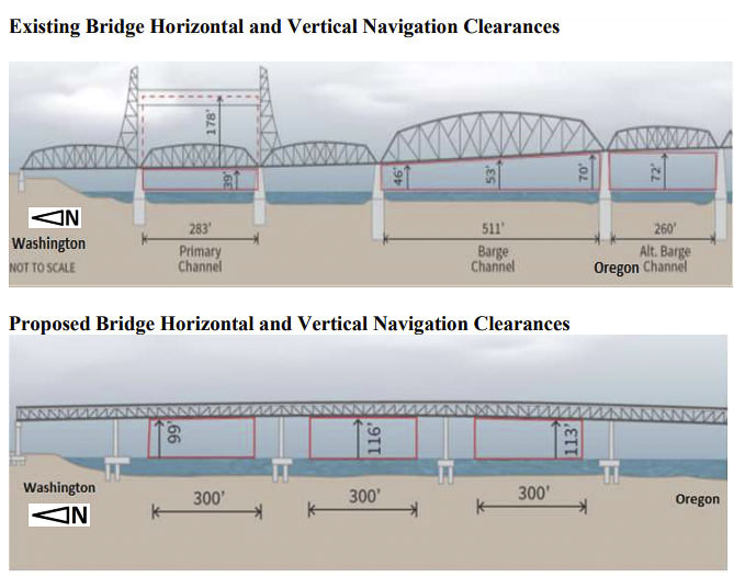
Interstate Bridge Replacement Program team proposed a bridge 116-feet high; Coast Guard says it needs to be at least 178 feet
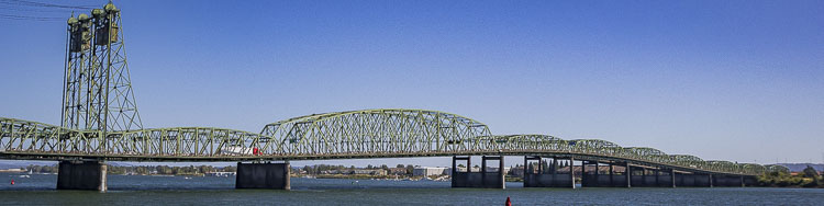
The U.S. Coast Guard recently revealed that any replacement of the existing Interstate 5 Bridge needs to have a vertical navigation clearance (VNC) of at least 178 feet, a significant contrast to the 116-foot height of the bridge the Interstate Bridge Replacement Program (IBR) team members have proposed.
The letter, dated June 17, provided a summary conclusion for Preliminary Navigation Clearance Requirements of the proposed I-5 Bridge replacement.
“The Columbia River System is an extremely important interdependent-multimodal supporting national and international commerce critical to local, national and global economies,’’ wrote B.J. Harris, chief of the Waterways Management Branch, Coast Guard District Thirteen. “Reducing the capability and capacity of the Columbia River System would severely restrict navigation. IBR’s proposed bridge … with its 35% reduction of VNC from 178 feet to 116 feet is contradictory to the U.S. Coast Guard’s mandate from Congress to maintain freedom of navigation on the navigable waters of the U.S. and to prevent impairment to U.S. navigable waterways.
“As new structures are built, navigation clearances should be improved or at a minimum maintained,’’ Harris continued. “Any proposed new bridge should have a VNC of greater than or equal to that of the existing I-5 twin bridges of 178 feet or preferable, unlimited VNC …’’
In his letter, Harris stated that alternative options are available and he even offered an example.
“There are alternative options to accomplish this VNC to include a tunnel or a high-level lift bridge or bascule bridge, which would provide an unlimited vertical clearance,’’ he wrote. “A modern similar successful project is the Woodrow Wilson Bridge over the Potomac River in Washington, DC that was completed in 2009. It is a higher-level double bascule lift bridge on an interstate (I-95) with transit. The added height of the new bridge reduced the number of bascule bridge openings for vessel passage by 76%.’’
At the June 17 Bi-state Bridge Committee meeting, the IBR team indicated that anything higher than 116 feet of clearance for the I-5 Bridge replacement would cause the IBR to have to go to a “moveable span.” Administrator Greg Johnson had indicated that the moveable span could cost $400 million. He further indicated “some things you want to be the biggest . . . but this isn’t one of them,” in reference to trying to design a bridge with a moveable span.
In light of the Coast Guard letter and requirement for 178 feet of clearance, Clark County Today asked Johnson if the IBR will now begin designing a bridge with a moveable span? And, if this significant change would alter the team’s timeline for entering the Supplemental Environmental Impact Statement (SEIS)?
“As the Coast Guard notes, this preliminary determination does not constitute an approval or final agency determination,’’ Johnson said. “The IBR program respects the Coast Guard’s focus on preserving navigation for the nation. While the Coast Guard is specifically charged with addressing the needs of navigation, the IBR program has a responsibility to identify a multimodal solution that not only addresses the needs of navigation but those of all program area users including air, transit, freight, vehicle, and active transportation.
“As new information becomes available, the navigation clearance identified may change,’’ Johnson added. “The Interstate Bridge.Replacement (IBR) program will continue coordinating with the Coast Guard and our other federal and regional partners to identify a solution that best accommodates river navigation while balancing the needs of other modes, including freight, automobile, bicyclists, pedestrians, transit, and aviation. In the next few months, the program will complete a written assessment to analyze the tradeoffs of a higher navigation clearance and a movable span. While the program’s hope is to avoid a lift span bridge option, the program will continue to closely coordinate with the Coast Guard to discuss the trade-offs and mitigation to accommodate river navigation, highway and air needs.’’
Johnson said the IBR team was not surprised by the Coast Guard’s response.
“Given that this preliminary determination from the Coast Guard was an anticipated part of the process, the IBR program does not anticipate an impact to the program timeline,’’ Johnson said. “The program does not anticipate receiving a bridge permit until the 2025/2026 timeframe, so work over the next few years will address program tradeoffs to balance regional needs. The program’s hope is that the upcoming movable span assessment will address current issues, in advance of the submission of the draft environmental documentation. Opportunities to avoid, minimize, or mitigate adverse impacts, such as potential modifications to vessel equipment, will be thoroughly investigated, as needed in the environmental and permitting process.’’
Johnson also offered a link to the Coast Guard preliminary determination which includes a summary memo of the next steps in the process.
The Coast Guard’s statement comes at a time when Johnson is visiting with area government agencies instead of partners seeking an endorsement for the IBR’s Locally Preferred Alternative (LPA). He has already made a presentation to the members of the Vancouver City Council, who are expected to vote on a resolution at a meeting scheduled for July 11. Members of the Clark County Council are also working on a response to the LPA.
In his letter, Harris also stated that in addition to the 178-foot VNC that any side channels from the U.S. Army Corps of Engineers (ACOE) approved main navigation channel/project “would require vertical clearances equal to or greater than 72 feet.’’
“Generally, the Coast Guard does not approve bridge proposals with vertical navigation clearances below the ‘present governing structure’ when the existing VNC has been and is currently needed unless there is a compelling navigational reason to do so,’’ Harris wrote. “The existing I-5 twin bridges are the ‘governing structure’ on the Columbia River west of the Glenn Jackson I-205 Bridge. They are the lowest navigational obstruction (bridge or overhead cable) between the I-205 Bridge and west to the confluence of the Pacific Ocean and the Columbia River.
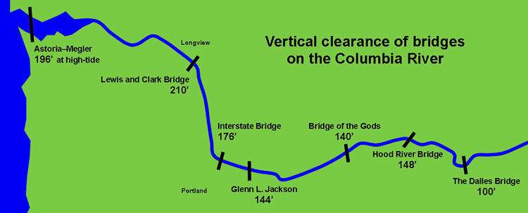
“Vessels with a VNCR of up to 178 feet have been able to navigate upriver from the Pacific Ocean since 1917, including past the first obstruction at the Astoria-Megler Bridge (with a vertical clearance of 193 feet),’’ he added. “The next four vertical clearance obstructions after the Astoria-Megler Bridge are between river miles 40 and 104 (with clearances ranging from 187 feet to 220 feet). A VNC of less than 178 feet would, for the first time in a century, decrease the present governing structure VNC by as much as 35% (reducing 178 feet to 116 feet). The next upriver VNC obstruction past the current governing structure is the Glenn Jackson I-205 Bridge approximately 6.75 miles upriver with a VNC of 136 feet to 144 feet.”
Harris wrote that “Multimodal Transportation Columbia River access facilitates the movement of products which are too large to truck or ship by rail. On-site barge access accommodates river and ocean-going vessels up to 400 feet in length, and with air drafts up to 178-feet tall. Outside storage capacity near the barge slips allows for unprecedented scale outdoor fabrication/assembly, staging and storage. CBC’s (Columbia Business Center) barge facilities are private and do-it-yourself in nature, eliminating red tape and outside controls and restrictions. CBC has accommodated construction of naval warships, yachts, oil rigs, bridge and dam components, and mass transit infrastructure. Dating back to its origins as a Kaiser shipyard and continuing to this day, the facilities at CBC allowed for prefabrication and special construction methods to efficiently produce products key to US national security and infrastructure. Whether the first occupant, Kaiser Shipyards; current tenants such as Greenberry Industrial, JT Marine, Thompson Metal Fab, or Vigor Industrial; or future tenants, it has always been the case that the vertical navigation clearance requirements of 178 feet under the Interstate 5 bridge have been critical to deliver products to and from markets.”
Also read:
- Opinion: IBR program’s $13-17 billion fraud and mismanagement, perpetuated by Vancouver Mayor Anne McEnerny-Ogle and Oregon Gov. Tina Kotek
 Gary Clark argues IBR hid a $17B cost estimate from lawmakers while spending up to $280M with no public benefit.
 - Opinion: The IBR shell game for TriMet at Ruby Junction
 IBR allocates $320M for a TriMet maintenance facility 20 miles from the actual bridge project.
 - Washington and Oregon transportation commissions discuss tolling options
 I-5 tolls could range from $1.55 to $4.70 depending on the plan, with final rates set in late 2027.
 - Letter: ‘That is why the process matters’
 The I-5 river bridge package is at roughly 30% design, meaning final construction drawings and final price are not yet set.
 - Letter: Forty years of Democrat governors’ judicial appointments
 Tom Schenk argues 150 Democrat-appointed judges shape Washington courts with no impartial check.