

Seismic retrofit is technically feasible per 2006 WSDOT report
The Cascadia Subduction Zone (CSZ) was only discovered 50 years ago. The science and understanding of how it moves and when and how an earthquake will impact the Pacific Northwest is still “young” in terms of science.
The fear associated with “the big one” has triggered many discussions and responses. FEMA’s Kenneth Murphy in 2015 said: “Our operating assumption is that everything west of I-5 will be toast.”
Washington Gov. Jay Inslee said “we do not have a choice” when he and Oregon Gov. Kate Brown signed a joint agreement to begin the Interstate Bridge Replacement Program (IBRP) in Nov. 2019. “This bridge could fall down any day, with a small seismic event,” said Inslee.
With over 75,000 Clark County and Southwest Washington residents daily commuting to Oregon for work (pre-pandemic), safe travel is a primary concern to area residents. The Southwest Washington Regional Transportation Council (RTC) reports 138,530 average weekday crossings in 2019 and 120,361 in 2020 for the Interstate 5 Bridge.
Yet the Washington State Department of Transportation (WSDOT) produced a report in 2007 that shows highways and bridges in Clark County and Southwest Washington are not the highest priority in a CSZ earthquake. In the simplest of terms, the further east you are, the less shaking and damage a CSZ quake would bring.
“WSDOT uses a map to identify different seismic zones with peak ground accelerations (PGA) in Washington based on US Geological Survey information. “Zone C” is considered “High Risk” and covers the area with PGA greater than 0.20 times the force of gravity. “Zone B” is considered “Moderate Risk” and contains an area of PGA between 0.10 and 0.20 times the force of gravity. “Zone A” is considered “Low Risk” and contains an area of PGA less than 0.10 times the force of gravity.”

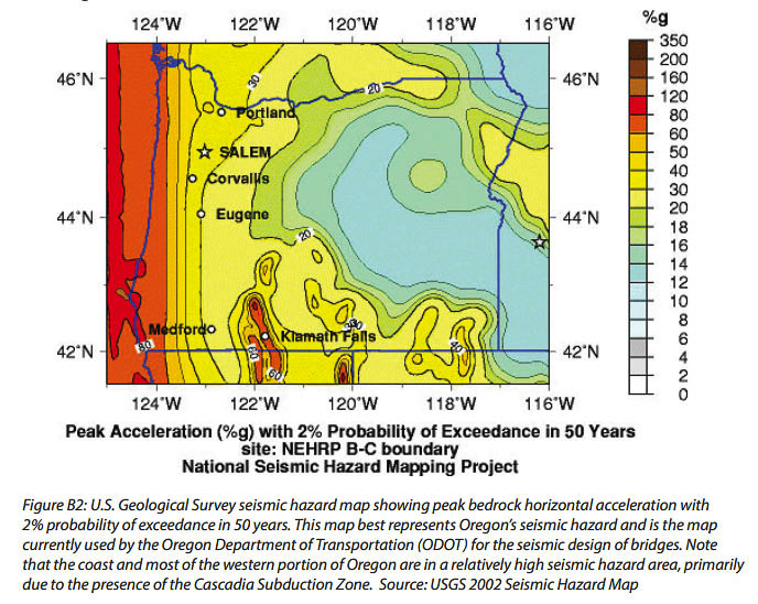
In 2014, the Oregon Department of Transportation (ODOT) updated an earlier report about the impacts of a major earthquake and its impact on roads and bridges in the state. “A Cascadia Subduction Zone earthquake with a magnitude of 8.0 or greater will hit Oregon; the question is when, not if. Such an earthquake will cause an unparalleled economic and human catastrophe for the state of Oregon,” the report began.
“Most bridges in western Oregon will suffer serious damage or destruction in a major seismic event because they were built before the existence of modern seismic codes. In addition, dozens of unstable slopes and pre-existing deep slides will fail during the extended three minutes or more of shaking produced by a large Cascadia event. Virtually all major highways will be closed in the immediate aftermath of a quake; it will take months to open many highways — and years before mobility is fully restored.”
The report identified 718 bridges needing work. Additionally, there were 1,185 landslide risk areas needing to be addressed, as the landslide areas could shut down major roadways for transportation. There were 138 bridges needing replacement, 390 bridges to be retrofitted, and 190 bridges to be rehabbed and retrofitted. The Interstate 5 Bridge was not included in the program, as the Columbia River Crossing was expected to replace it.
In Washington, WSDOT is responsible for nearly 3,000 vehicular bridges on state owned highways. They identified 895 bridges requiring retrofit, with 659 remaining to be addressed in 2007. The 2005 Transportation Partnership Program funded retrofit on 172 of the 604 bridges in the Puget Sound region. The final phase of the program was estimated to cost $470 million according to the 2007 report.
The cost of either doing seismic upgrades or replacing all the vulnerable Oregon bridges was $4.05 billion according to ODOT. The cost of addressing the landslide risks was $1.08 billion. The total cost was $5.13 billion.
To address the problem, ODOT proposed a 5-phase “Seismic Plus Program” to address these transportation needs. ODOT identified its priority as follows.
“In case of a major seismic event in Oregon, the main help for affected areas is expected to come from the eastern part of our state and from our neighbor states. Redmond Airport will be used as the main hub for providing goods and medical supplies for those in need. Therefore, creating a resilient highway system that would provide East-West freight movement becomes an important task for our program. Because Phase 1 will serve as the cornerstone of the entire program, a smart corridor selection becomes critical for the success of this program.”
Phase one addressed the most critical needs, to provide transportation corridors to serve the largest number of citizens by repairing five specific sections of highways. First was upgrading US 97, running north-south through central Oregon from I-84 to the California border. Relief supplies could be brought in from California and other states to be distributed throughout much of the state on this highway.
I-84 would be upgraded from I-205 to US 97 as the second priority. Third was upgrading I-205 from the border with Washington to where it joins I-5 near Wilsonville. Fourth was upgrading I-5 and OR 22 from I-405 to OR 58 near Salem. And 5th was upgrading OR 59 from I-5 to US 97 in central Oregon.
The total cost of ODOT’s Phase one was estimated to be $936 million.

Upgrading I-205 in the first phase would seem to make sense. It is the newest and therefore needs fewer repairs and upgrades. The Glen Jackson Bridge was completed and the freeway opened in Dec. 1982.
Most of I-205 is further east, and will get a smaller amount of ground acceleration than I-5 in the downtown Portland/Vancouver area during a CSZ earthquake. Plus the liquefaction issue will be more prominent along the parts of I-5 right next to the Willamette River, on Hayden Island and downtown Vancouver where road and bridge foundations may not be on solid bedrock.
ODOT spokesman Don Hamilton provided the following update on their progress.
“Our operations projects frequently coincide with the lifeline routes so we accomplish additional work on the lifelines outside of the seismic funding.
“For the HB2017 funding we are now funded for two sites on OR58, 3 sites on OR140, and 4 sites on I-5.
“The OR58 sites are currently in the Advance Investigation phase that has been funded for $750,000. We have $1.85M allotted to PE and $7.4M allotted to Construction in the 2022-2024 STIP.
“The OR140 and I-5 sites are part of the Southern Oregon Seismic Triage effort that is part of the Seismic Lifelines program. They are currently in the PE phase with a total of $14,775,000 programed for PE and Construction in the 2022-2024 STIP.
“All of these projects are in the preliminary design phase so only a small portion of the funding has been spent. “
Hamilton indicated phase one seismic work on US 97, I-84, and I-205 are in various stages of completion.
KGW news interviewed ODOT officials indicating the following about regional bridge damage in a “major” (undefined) earthquake.
Columbia River Bridges
- Interstate Bridge (I-5) — Collapse. Counterweights make this bridge vulnerable. Approaches could fail due to liquefaction.
- Glen Jackson Bridge (I-205) — Moderate Damage. Built very close to current code, designed for seismic activity.
Willamette River Bridges
- St. Johns Bridge — Extensive Damage. Approaches are very vulnerable to major damage or collapse.
- Fremont Bridge — Moderate Damage. Fairly resistant due to design style. Approaches could collapse.
- Broadway Bridge —Collapse. Bridge could fall from its supports, piers and columns could fail.
- Steel Bridge — Collapse. Counterweights and design put this bridge at great risk.
- Burnside Bridge — Extensive Damage. Bridge could fall from supports, piers and columns could fail.
- Morrison Bridge — Extensive Damage. Could have column failure. Approaches are at risk.
- Hawthorne Bridge — Collapse. Deck surface could slide off pier. Counterweights create risk.
- Marquam Bridge (I-5) — Extensive Damage. Bridge could fall from supports, piers and columns could fail.
- Tilikum Crossing — Minor Damage. Built to high standards for seismic resiliency.
- Ross Island Bridge — Collapse. Highly vulnerable to shaking. Won’t flex, likely to crumble.
- Sellwood Bridge — Minor Damage. Built to high standards for seismic resiliency.
In a recent discussion of IBRP issues with several Hayden Island residents, they were asked what made the most sense to them. Should Oregon spend $5.1 billion to upgrade all Oregon’s roads and bridges to current seismic standards, or spend $4 to $5 billion to replace the Interstate Bridge? They unanimously agreed the money would be better spent addressing the seismic needs of the entire state.
Last November, the IBRP team provided the Bi-state Bridge Committee of 16 legislators a cost estimate for the project. It ranged from a low of $3.17 billion to a high of $4.81 billion. They provided high and low scenarios for including light rail in the project, or including bus rapid transit.
In May, Ray Maybe, IBR Assistant Program Administrator and ODOT State Bridge Engineer shared the following with Clark County Today. “Even if the existing bridge were to be retrofitted, it is not practically feasible to bring it up to modern seismic standards or fully address the safety issues associated with the existing roadway design.”
Kellianne Amico of the IBRP shared today: “The IBR program team includes individuals with national seismic expertise. The program is supported by a consultant team with a wide range of specialized expertise and global experience on multimodal bridge mega projects, as well as experience in the local communities, led by WSP in close collaboration with Parametrix and supported by talented specialty and local firms.
“The numerous seismic vulnerabilities with the existing Interstate Bridge that have been identified in previous studies remain valid. As noted in our previous response (attached for reference):
- Based on the most recent ODOT estimate, a conceptional cost of roughly $600 million (in 2014 estimated dollars) was identified as needed for seismic upgrades, though as previously noted it is not possible to retrofit to the same standards as a new bridge.
- Given that both states have identified replacement of the I-5 bridge as a priority to address the multiple transportation problems in the bridge corridor, the significant estimated cost of a retrofit previously identified, and the impact on vehicular and marine traffic, it would be impractical to spend the resources to do a more detailed analysis on retrofit costs of the Interstate Bridge.”
IBRP Administrator Greg Johnson has said they will replace the Interstate Bridge.
A 2006 WSDOT report indicates a seismic upgrade to the Interstate Bridge structures was technically feasible.
“The Panel discussed and developed their opinion of estimated raw bridge construction costs to retrofit both bridges. This opinion ranges from $88 million to $190 million. This opinion of cost increases from $125 million to $265 million when design, permitting, right-of-way, construction inspection and management, agency oversight, and contingencies are added.”
The cost estimates included “retrofit cost of $47 million for the foundations and $6.3 million for bearings.” They also reported the site will likely experience liquefaction during a 500-year seismic event (to depths of about 50 feet, and to depths of about 60 feet under the 1,000-year event).
Current ODOT Director Kris Strickler was part of the WSDOT team on the seismic evaluation project. Frank Green was there as well, and he currently is part of the IBRP team.
Given the billions of taxpayer dollars required to seismically address both Oregon and Washington highway and bridge deficiencies in a CSZ earthquake, citizens might wonder why legislators, governors, and DOT directors aren’t pushing for the most cost effective solutions.