

Odds of a megaquake are roughly one in 10 in the next 50 years
Last Thursday, Oregon and Washington held “the great shakeout” to raise awareness about what to do in an earthquake. On Sunday, there was a 4.7 earthquake about 110 miles off the Oregon coast from Coos Bay. Twenty years ago, the Nisqually earthquake shook Washington state for about 45 seconds at a magnitude 6.8. It was located northeast of Olympia. There was a magnitude 7.7 earthquake southwest of Prince Rupert, British Columbia in 2012.
In the past, significant earthquakes occurred in Washington state on April 29, 1965 (magnitude 6.7, depth 37 miles), and April 13, 1949 (magnitude 6.7, depth 31 miles). Geologists report there are shallow or crustal quakes, deep earthquakes, and the subduction zone earthquakes. The “megaquake” Cascadia Subduction Zone (CSZ) only happens when the full fault line ruptures.
Two years ago, Oregon State University geologist Chris Goldfinger was asked if a small series of earthquakes like Sunday’s tremor could trigger a rupture of the CSZ. He is considered one of Oregon’s best experts on Cascadia.
“The only way a little quake like this could trigger a big earthquake, is if the fault was already ready to go, and was basically locked and loaded, and it just needed a little more to shove it over the edge,” he said. “As far as we know, that’s not true at this point.”
Two years ago, Gov. Jay Inslee said “we do not have a choice” when he and Oregon Gov. Kate Brown signed a joint agreement to begin the Interstate Bridge Replacement Program (IBRP) in Nov. 2019. “This bridge could fall down any day, with a small seismic event,” said Inslee.
Yet the two Interstate Bridge structures did not fall down in the magnitude 6.8 Nisqually earthquake in 2001. Nor did the bridge fall down in the 1949 or the 1965 earthquakes.
Some will point out that these earthquakes were not strong enough to trigger “liquefaction” of the soil the foundation of most bridges in the region are built on, and that is the biggest risk.
“Two conditions must exist for liquefaction to occur: The soil must be susceptible to liquefaction (loose, water-saturated, sandy soil, typically between 0 and 30 feet below the ground surface). Ground shaking must be strong enough to cause susceptible soils to liquefy,” according to the Utah Geological Survey.
Understanding earthquakes and the Cascadia Subduction Zone (CSZ) is key to making informed decisions regarding transportation infrastructure in the area and seismic resilience for homes, hospitals, and the places we work and play. The magnitude of an earthquake is reported on a logarithmic scale, so an 8.0 quake is 30 times more powerful than a 7.0 quake; and a 9.0 is 900 times more powerful than a 7.0 quake (30 times 30).
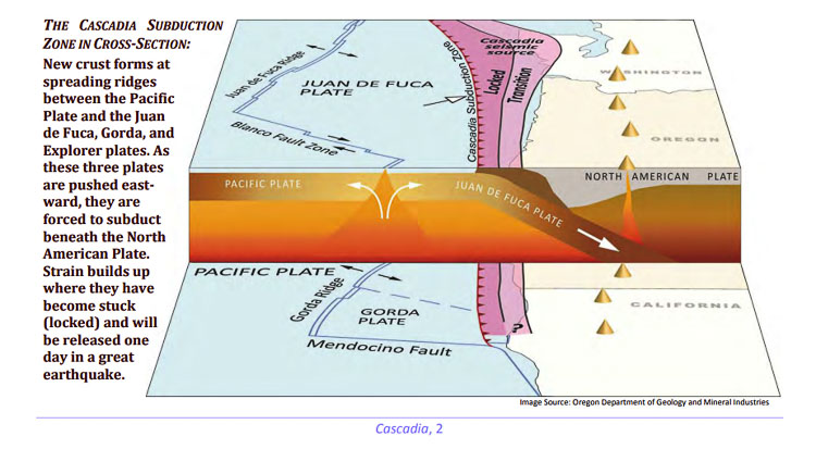
The CSZ is roughly 700 miles long, running from Vancouver Island, British Columbia to northern California. The Juan de Fuca plate zig zags off the coast, roughly 300 miles off shore from Seattle and is sliding under the North American plate, roughly 20-30 miles below Seattle and Portland. The subduction zone is roughly 60 miles offshore.
The geography of northern California, Oregon, Washington, and southern British Columbia is shaped by the CSZ. The North American plate is moving west and collides with a number of smaller plates. The largest is the Juan de Fuca plate, flanked by the Explorer plate to the north and the Gorda plate to the south.
These three smaller plates are being pinched between the Pacific plate and the North American plate. They “subduct” (descend) beneath the North American plate as they converge along the 700-mile long boundary. A large portion of the boundary between the subducting and overriding plates resists the convergent motion. It is “locked” until this part of the boundary breaks in a great earthquake.
Evidence for at least 13 great earthquakes on the Cascadia subduction zone was discovered on top of a 7,000-year-old volcanic ash deposit from Crater Lake in Oregon. The most recent of these earthquakes is estimated to have been between magnitude 8.7 and 9.2 and occurred on the evening of January 26, 1700. It can be dated precisely because the giant tsunami that Cascadia triggered flooded coastal villages in Japan and was recorded by officials there.
Nick Zentner teaches geology at Central Washington University in Ellensburg. He delights in sharing what the evidence shows us about the earth. He points out that the Cascade Mountain Range is almost the same length as the CSZ. Is that a coincidence? He doesn’t think so.
Zentner has worked with other scientists around the northwest and has provided a rough timeline for past ruptures of the CSZ fault line. He highlights significant ruptures of the CSZ in 1700 AD, 700 AD, 380 AD, 550 BC, and 950 BC, citing geologic evidence in the dirt and sands near Grays Harbor, other offshore evidence in the Pacific Ocean, and even in volcanic ash.
USGS and M9 Project seismologist Erin Wirth shows one of 50 simulations the M9 Project created showing the possible impact of a Cascadia Subduction Zone magnitude 9 earthquake. The impact is greater in this scenario in Crescent City than it is in Portland and Seattle due to Crescent City being closer to the subduction zone. Video courtesy Pacific Northwest Seismic Network
The M9 Project is a team of University of Washington scientists specifically evaluating the risks and possibilities of a magnitude 9 or greater CSZ earthquake. These scientists make guesses on how often earthquakes might happen, what the impacts including tsunami and coastal damage and flooding might be, and the damages to buildings and infrastructure in northwest cities.
The M9 project created 50 different computer simulations of CSZ ruptures, all with varying outcomes.The impacts depend on where the earthquake starts (on shore or offshore), the direction of movement, and a host of other variables, according to seismologist Erin Wirth with the US Geological Survey.
In one scenario, Crescent City had much worse shaking than Portland, Seattle, or La Grande. That was because it is on the coast and much closer to the megathrust offshore, according to Wirth.
Last decade, Zentner held a presentation indicating the likelihood of the top five earthquake scenarios. The greatest threat in the next 50 years is an 84 percent chance of a magnitude 7.0 Puget Sound Deep Fault earthquake, like the Nisqually quake. Next up was a 25 to 40 percent chance of a magnitude 8.0 Partial Rip of the Cascadia Trench. A “full rip” of the CSZ with a magnitude 9.0 quake was seen as a 14 percent chance of happening in the next 50 years.
In 2013, the Cascadia Region Earthquake Workgroup (CREW) working with FEMA and the National Earthquake Hazard Reduction Program (NEHRP) published an extensive report indicating there was a 10 percent chance of the M9 CSZ quake in the next 50 years.
“We say that there’s approximately a 14 percent chance of another approximately magnitude-9 earthquake occurring in the next 50 years,” said Wirth in a Feb. 2020 news report.
Think of the movement of plates together as the compression of a spring. Every year the North American plate pushes on the Juan de Fuca plate about 1.6 inches of compression. As the spring gets compressed, it also pushes upward the land being compressed. The west coast along the plate gets higher in elevation.
Zentner also likes the analogy of a diving board at a swimming pool. The “spring” of the diving board pushes down and then pushes you back up into the air with all the energy “stored” from the downward pressure on the board.
He works with Goldfinger, the OSU paleoseismologist. He notes the Cascadia Subduction Zone is actually far quieter than similar fault zones around the world, like the San Andreas Fault in California and in Japan, Alaska, and other locations on the “ring of fire” of the Pacific.
Goldfinger has studied soil samples from underwater canyons off the west coast of the Pacific Ocean. He has found evidence of large underwater landslides and movements that seem to indicate ruptures of the CSZ.

The movement of these plates is neither constant nor smooth. The plates are stuck, and the stress will build up until the fault suddenly breaks. This last happened in 1700: the result was an earthquake in the range of 8.7 to 9.2 according to the CREW report. It was followed within minutes by a large tsunami — much like the earthquake and tsunami that struck Japan on March 11, 2011. Stresses have now been building along the Cascadia subduction zone for 320 years.
The most likely scenario is a southern CSZ quake, with an 8 to 8.6 magnitude off the coast of southern Oregon and northern California according to the geologists. This is over 300 miles away from Portland. They also report the CSZ almost never has a “small” rupture or release of the energy in the locked plates.
Historically, the geologists estimate there have been 41 mega-quakes over 10,000 years. They have ranged from magnitude 7.6 to 9.2, and averaged every 246 years according to the data they have compiled. Yet half of them were less than 8.5 according to the estimates.
When a full rupture of the fault happens, all that stored energy will be released. (Picture the pinched spring suddenly expanding outwards). The northwest edge of the coastline will drop up to 6.6 feet in elevation and rebound, extending 100 feet or more further west.
Zentner provides another description.The crust leading edge under the water, moves 150 feet to the west. Ocean Shores, WA moves 50 feet west and simultaneously moves 30 feet down.
Seattle moves 6 feet west and Ellensburg moves 10 inches, because It’s 250 miles inland.
All this happens in a 4 to 5 minute span. The western part of the state “opens up like an accordion,” Zentner explains.
Because the epicenter of the earthquake will be offshore, by the time the intensity and energy of the earthquake reaches the Seattle and Portland areas, most experts predict it will be in the 6 to 7 magnitude range of intensity.
This sudden movement of land usually triggers a tsunami. (Although a recent 8.2 Alaska earthquake July 2021 didn’t cause a devastating tsunami.) Geologists are predicting that the tsunami caused by a CSZ rupture could cause up to 70 percent of the deaths, with the major risk being along the coastline of Oregon, Washington, and British Columbia.
“The largest Alaska earthquake since 1965 caused a tsunami warning and local evacuations along the southwest Gulf of Alaska coast,” news reported. “After tsunami waves of less than 1 foot arrived onshore, the warning was canceled and coastal residents returned home.”
The tsunami caused by the magnitude 9.0 Tohoku earthquake in 2011 produced as many as five large waves in some places, the last arriving more than two hours after the earthquake. The tsunami that struck Chile after the M8.8 Maule earthquake in 2010 consisted of three to four waves — the last tended to be the largest and reached shore as many as four hours after the earthquake, according to the CREW report.
Therefore the highest levels of risk are along the Washington, Oregon, and Northern California coastline. The time of year and a variety of conditions cause wide variations in estimates of death and injuries. Some scenarios predict wave heights of 20-26 feet along the Washington coast.
According to the CREW report:
The evidence for past earthquakes of magnitude 9.0 suggests that they recur on average every 500 years, but the actual intervals between events are far from predictable—such earthquakes have been separated by as many as 1,000 years and as few as 200. The estimates of the sizes of pre-1700 earthquakes are also uncertain.
Cascadia has now been building up strain for over 300 years, so the next great earthquake could happen at any time. Reduced to simple odds, the chances that an earthquake as large as magnitude 9.0 will occur along the zone within the next 50 years are about one in ten.
Clark County Today reached out to one of the experts and asked for clarification. It takes a certain amount of stored energy to trigger an M9 earthquake. If the “average” time between M9 earthquakes is every 500 to 1,000 years, and if it has been only 320 years since the last megaquake, then we haven’t built up enough stored energy to trigger a magnitude 9 CSZ quake. If it were to rupture today, it would be highly likely it would be significantly less than 9.0 in magnitude.
Goldfinger doesn’t believe there is enough stored energy along the CSZ to trigger the unlocking of the plate and the megaquake at this time.
What is not known, is when a megaquake happens, does the stored energy go back to zero. It’s possible “most” but not all energy is released by the rupture of the locked plates. Therefore the January 1700 earthquake may not have reset the stored energy level back to zero.
However it is highly likely that it will take much longer than the next 50 years for the moving plates to store up enough energy to trigger a full rupture of the CSZ with a megaquake up to an M9 level.
Harold Tobin, director of the PNW Seismic Network shared at the 2019 Pacific Northwest Earthquake Forum, a video highlighting 40 years of earthquakes. ”Oregon is pretty boring,” he said, noting most of the earthquakes have been in California, Washington, or offshore.
Harold Tobin, director of the PNW Seismic Network highlights all the earthquakes since 1980. The largest earthquake ever recorded was in Chile in 1960. Graphic courtesy Tsunami Warning Center and Pacific Northwest Earthquake Forum
But as the geologists and scientists always say, they are constantly looking for new evidence to help them better understand the earth and the plate movements and fault lines that exist around the globe.
This takes us back to Inslee’s claim “we don’t have a choice” to replace the Interstate Bridge. It appears that may not be the case.
The Utah Geological Survey reports:
The liquefaction potential categories shown on liquefaction maps depend on the probability of having an earthquake within a 100-year period that will be strong enough to cause liquefaction in those zones.
- High liquefaction potential means that there is a 50 percent probability of having an earthquake within a 100-year period that will be strong enough to cause liquefaction.
- Moderate means that the probability is between 10 and 50 percent.
- Low means that the probability is between 5 and 10 percent.
- Very low means that the probability is less than 5 percent.
Using UGS as a guide, the PNW is in the “low” or bottom of the “moderate” range of liquefaction risk, with a CSZ potential being 10 to 14 percent chance in the next 50 years.
A spokesperson for the Interstate Bridge Replacement Program (IBR) told Clark County Today:
“We have not yet established the level of earthquake the structure will be required to withstand, but during the previous project the Interstate Bridge over the Columbia River was required to withstand a 2500-year earthquake (referred to as a maximum credible earthquake).”
Liquefaction is only likely to occur with the combination of strong shaking (high magnitude earthquake) and longer duration of the shaking that a CSZ type earthquake could cause. But there is an 86 percent to 90 percent likelihood that won’t happen in the next 50 years according to the best estimates of the experts.
Oregon Department of Transportation (ODOT) has estimated that 19 of the bridges on I-5 are likely to be heavily damaged during a great subduction zone earthquake, and five are likely to collapse. Of the 135 bridges carrying U.S. 101 on the Oregon coast, ODOT estimates that 56 may collapse and 42 may be heavily damaged.
ODOT officials further report “little redundancy has been built into the transportation system, in part because of the Pacific Northwest’s steep mountain ranges and inland waterways (notably,the Columbia River, Puget Sound, and straits around Vancouver Island). It may therefore be hard to find detours around many of the damaged sections” according to the CREW report.
That sounds like a call for more “redundancy,” new transportation corridors, and routes for detours.
The Washington State Department of Transportation began its retrofit program in 1991 and is much further ahead of Oregon in addressing seismic issues for roads and bridges.