

At project completion, the highway will have been widened so three travel lanes run along the full length of SR 14 in both directions between Southeast 164th Avenue and I-205
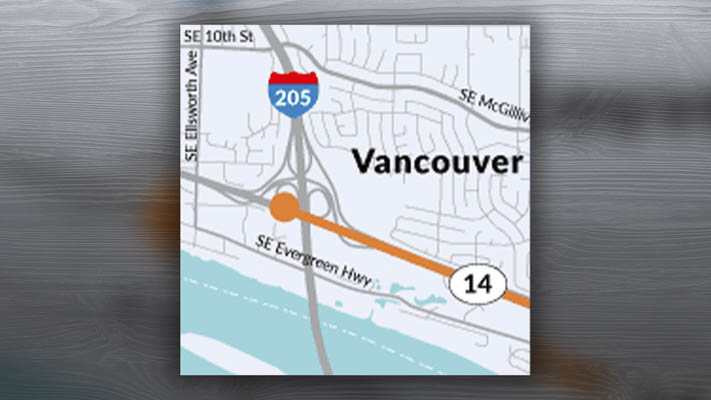
VANCOUVER – Following the Memorial Day weekend, work on State Route 14 in Vancouver between Interstate 205 and Southeast 164th Avenue will resume after pausing for the winter.
On Tuesday, May 28, Washington State Department of Transportation’s contractor, Rotschy, Inc., will pave a test section of the left lane along eastbound SR 14. This is to calibrate test equipment and make sure the asphalt meets our specifications.
Between Wednesday, May 29, and Monday, June 3, existing lane striping will be removed and replaced with temporary striping. This will set up the permanent three-lane configuration in both directions and ensure the pavement joints align with the permanent lane lines when the highway is paved.
What travelers need to know
- Nightly closures from 7:30 p.m. to 5 a.m., Tuesday, May 28, Wednesday, May 29, Thursday, May 30, there will be left and right lane closures on eastbound SR 14 between I-205 and Southeast 164th Avenue.
- Nightly closures from 7:30 p.m. to 5 a.m., Friday, May 31, Monday June 3: there will be left and right lane closures on westbound SR 14 between I-205 and Southeast 164th Avenue.
When weather permits, final paving of SR 14 will take place.
At project completion, the highway will have been widened so three travel lanes run along the full length of SR 14 in both directions between Southeast 164th Avenue and I-205. This stretch of SR 14 often experiences congestion during peak travel times due to frequent lane changes and merges near the interchange.
In addition to the new three-lane configuration, this project will introduce a part-time shoulder lane on westbound SR 14. This lane will allow travelers heading to northbound I-205 to use the right shoulder during heavy traffic, creating an extra lane of travel (i.e., three lanes will become four).
This project is expected to wrap up by fall 2024.
Know before you go
People can receive real-time travel information via the WSDOT mobile app, or by visiting our real-time travel map.
Also read:
- Final Supplemental Environmental Impact Statement published for Interstate Bridge Replacement Program
 Federal agencies published the final environmental impact statement for the Interstate Bridge replacement project.
 - Speed cameras designed to bring added safety to work zones
 WSP issued 65,000 infractions in first year, with 59,000 being penalty-free first offenses as program expands statewide.
 - Marie Gluesenkamp Perez seeks federal assistance in combating sea lion predation of salmon & steelhead fishing stock
 Congresswoman pushes for expanded lethal removal authority as sea lions devour Columbia River fish stocks.
 - Opinion: The high cost of hiding – Why IBR’s delayed revenue study is a $15 billion warning sign
 IBR delays critical toll revenue analysis until June 2027, hiding financial details until after project approval.
 - Opinion: The high cost of hiding – Why IBR’s delayed revenue study is a $15 billion warning sign
 IBR delays critical toll revenue analysis until June 2027, hiding financial details until after project approval.