

Limited closures implemented following South Coldwater Slide
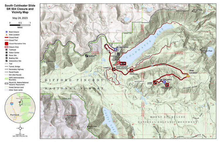
Many recreational sites remain open to explore at Mount St. Helens National Volcanic Monument following a May 14, 2023, debris flow, known as the South Coldwater Slide. The debris flow damaged the upper portion of State Route 504 near milepost (MP) 49 leading up to the Johnston Ridge Observatory north of Mount St. Helens. The area impacted only affects the last eight miles of SR 504 and some associated trailheads and recreation sites.
The highway remains open to MP 43 near the Science and Learning Center at Coldwater. Multiple scenic viewpoints, including Elk Rock (MP 37) and Castle Lake (MP 40) are still accessible. Several visitor center options including the Mount St. Helens Forest Learning Center at MP 33 and Washington State Park Mount St. Helens Visitor Center at Silver Lake off SR 504, near Castle Rock remain open with opportunities to view Mount St. Helens and learn about the history, eruption and recovery of the volcano.
On May 23, 2023 Gifford Pinchot National Forest implemented a forest closure order that includes the Coldwater Lake Picnic and Boating Recreation Site, Hummocks Trailhead Parking Lot, Hummocks Trail #229, from Hummocks Trailhead to junction with Boundary Trail #1, Boundary Trail #1 from the junction with the Hummocks Trail #229 to the Hummocks Trailhead, Lakes Trail #211 from Trailhead to junction with Coldwater Trail #230, the South Coldwater Trailhead Parking Lot, and South Coldwater Trail #230A from Trailhead to junction with Coldwater Trail #230. The U.S. Forest Service is exploring alternative options to accommodate visitors who would like to visit the north side of the Mount St. Helens National Volcanic Monument this summer. More information about this will be shared when available.
The upper portion of SR 504, to the terminus at Johnston Ridge Observatory, remains closed and inaccessible by vehicle. Visitors should not venture beyond the highway closure at MP43 due to the instability of the hillside.
It is too soon to tell when the highway may reopen. Engineering geologists are assessing preliminary aerial data to help determine when ground access to the slide area can occur. The U.S. Forest Service and Washington State Department of Transportation (WSDOT) are actively gathering and analyzing data to help inform next steps. As snow melts and U.S. Forest Service roads reopen for the season, additional recreational sites on the Mount St. Helens National Volcanic Monument’s south and east sides and in the surrounding areas will open for visitors to explore.
For U.S. Forest Service information visit http://www.fs.usda.gov/goto/gp/coldwaterslide.
For WSDOT information, visit https://wsdot.wa.gov/construction-planning/search-projects/sr-504-landslide-bridge-washout.
South Coldwater Slide Closure and Vicinity Map: https://www.fs.usda.gov/Internet/FSE_DOCUMENTS/fseprd1109688.pdf
Also read:
- Letter: ‘That is why the process matters’
 The I-5 river bridge package is at roughly 30% design, meaning final construction drawings and final price are not yet set.
 - Letter: Forty years of Democrat governors’ judicial appointments
 Tom Schenk argues 150 Democrat-appointed judges shape Washington courts with no impartial check.
 - Work begins this month to improve intersection at Northeast 182nd Street and Risto Road
 A new single-lane roundabout replaces the existing intersection at Northeast 182nd Avenue and Risto Road starting June 22.
 - POLL: Would you support upgrading and reusing the existing Interstate Bridges if it saved billions of dollars?
 Rep. John Ley questions whether $400M in bridge demolition costs could be redirected to other regional transportation needs.
 - Letter: TriMet’s history of over-predicting light rail ridership
 TriMet’s MAX Green Line carried ~10,000–11,000 weekday riders in 2024–2026, less than a third of its 2020 forecast.