

A strong La Nina in the Pacific is likely to send more rain into the Pacific Northwest early, with cooler weather later in the winter
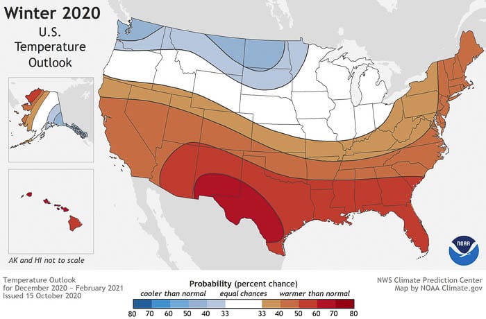
CLARK COUNTY — The National Oceanic and Atmospheric Administration (NOAA) released their winter weather outlook late last week, and colder and wetter are the key words for the Pacific Northwest.
Whether that will equal more snow at lower elevations is still open for debate, however, says Meteorologist Tyler Kranz with the National Weather Service in Portland, Ore.
“Looking at past years where we had La Nina conditions, we actually see that October, November and December, our temperatures are actually near normal,” says Kranz. “And in some cases, even a little bit above normal.”
That said, Kranz does expect we will see more rain than typical for the remainder of 2020, which could spell good news for people hoping to be able to go skiing in time for Thanksgiving.
“La Nina definitely favors good snowpack in the Cascades,” says Kranz, “something we haven’t really seen a whole lot of the past few winters.”
While the possibility of lower-elevation snow is not out of the question before January, Kranz says the best chance this Winter will likely be in January and February, or even into March, which is typically the most active period for potential snow in the Pacific Northwest.
“We’re kind of missing the bulk of the coldest air until later in the winter,” says Kranz. “So yeah, I would say January and February would be the best chance for us to see those truly colder temps and events such as low elevation snow.”
Even as long range weather forecasting has come a long way from the days of the Old Farmer’s Almanac, the Pacific Northwest presents a unique set of challenges for even the most advanced computational models.
“It’s mainly due to the lack of observations that we have to our west,” says Kranz. “We have a big ocean out there with hardly any observations at all.”
Instead, forecasters are left using satellite imagery and computer modeling, which often fails to fully account for the myriad of geographical features which impact weather around here, such as the Cascades, the Coast Range, variations in elevation and, perhaps most impactfully, the Columbia River Gorge.
“It could be the difference of just one degree,” Kranz says. “Your observations could come in one degree warmer than your forecast, and that could be all it takes to have your precipitation type fall as a cold rain, rather than a wet snow.”
Forecasters tend to look at what’s known as an analogue when trying to predict how atmospheric and oceanic conditions might impact global weather, meaning they compare years with similar conditions. However, climate modeling has proven to be a tricky science, with nearly limitless variations that can impact what ultimately happens.
Kranz says computer simulations, as well as a high resolution weather satellite known as GOES-17 or GOES-West, which went live in February of 2019, and years of observation have helped to improve long-range forecasting. Still, when it comes to determining exactly when snow might fall in the valley, or how much, even the best technology falls short.
It’s why forecasters at the National Weather Service are focusing less on predictions and more on probabilities.
“We’re trying to stray away from messaging like that, and explaining more the range of possible outcomes,” explains Kranz, “so that people can prepare for the worst case scenario, the best case scenario and the most likely scenario.”
Making matters more difficult is the proliferation of weather apps on every smartphone.
“Every winter we’ll get a flurry of phone calls if the app on their phone has a snowflake symbol,” says Kranz, pun apparently not intended. “It’s just some random model that the app uses that the viewer is seeing, and half of them don’t even realize that’s not our forecast.”
Kranz says they encourage people to follow them on Twitter (@NWSPortland) and, of course, pay attention to what local forecasters are saying. They may not end up being right, but they’re almost certainly going to be more accurate than the weather app on your phone.