

Visitors to Johnston Ridge Observatory should expect an extended closure of the highway after landslide washed out bridge
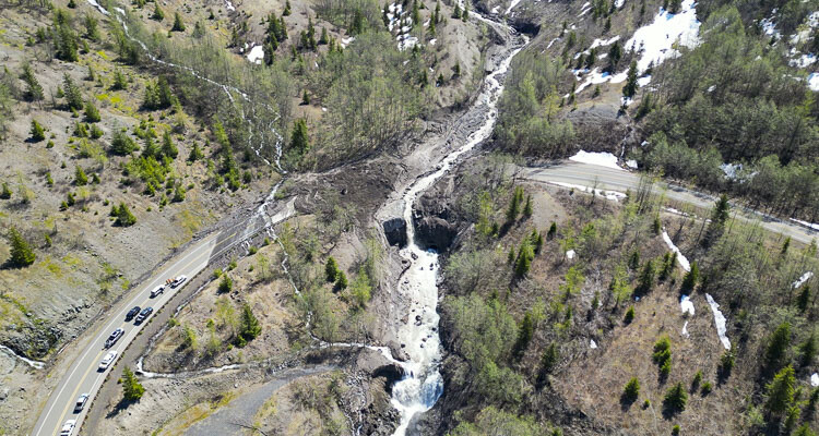
TOUTLE – The upper portion of State Route 504, which takes travelers to the Johnston Ridge Observatory located within the Mount St. Helens National Volcanic Monument, will remain closed until further notice following a massive debris slide. Due to the size of the slide and the instability of the hillside above the highway, the Washington State Department of Transportation does not know when the road will reopen.
The highway closed shortly after 9 p.m. Sunday, May 14, when debris from an adjacent hillside fell about 2,000 feet and covered the roadway with rock, mud, ice, and water causing catastrophic damage to the Spirit Lake Outlet Bridge. Engineers need to examine the hillside above the roadway and debris below to develop next steps.
“Additional safety analysis is needed, but due to the ongoing geological instability in the area, it’s too soon to tell when we’ll be able to safely do that work,” said Brad Clark, WSDOT Southwest Region Maintenance Manager. “We appreciate everyone’s patience during this emergency.”
Spirit Lake Memorial Highway is closed to all travelers at milepost 43 near the Science and Learning Center at Coldwater. The closure blocks access to Coldwater Lake and the Johnston Ridge Observatory as engineers work to assess the debris flow and ensure for public safety. There is no detour available. WSDOT strongly encourages visitors to not venture beyond the closure location due to the severity of the unstable hillside – the closure is in place for everyone’s safety.

WSDOT is working in coordination with the U.S. Forest Service, U.S. Army Corps of Engineers, U.S. Geological Survey, and Skamania and Cowlitz counties in evaluating slope conditions. This work will help inform what steps are needed to stabilize the slope, cleanup, and rebuild the roadway and bridge.
The cause of the landslide is yet to be determined, though initial assessment is that unseasonably hot temperatures likely drastically melted snowpack which oversaturated soils and overfilled the channels of the slopes causing debris to join high water, which built up and then broke free, rolling downstream washing out the 85-foot bridge span and roadway.
There is currently no timeline for this work. Travelers should plan for the highway to be closed for an extended period.
Drivers can stay informed on the latest traffic issues by visiting WSDOT’s recently updated real-time travel map, or by following WSDOT’s southwest Washington-area Twitter account. To stay up-to-date with which Forest Service facilities are open, check out the GiffordPinchot National Forest website.
Also read:
- High school sports notes: Seton Catholic earns another Scholastic Cup
 Seton Catholic’s 15 postseason teams and 10 academic state titles powered a third straight Class 1A Scholastic Cup.
 - Clark College celebrates the 90th Graduating Class of 2026
 Clark College’s 90th commencement conferred 2,816 degrees and certificates, a 49% increase over 2025.
 - Vancouver Bee Project presents annual Pollinator Festival on Saturday, June 20
 The 2026 Vancouver Pollinator Festival brings 60+ vendors, speakers, and walking tours to Marshall Park on June 20.
 - Letter: I-5 Bridge – Save $billions, reduce congestion and improve safety
 Camas resident Douglas Tweet argues eliminating light rail could save $2.5 billion and reduce bridge width by 31 feet.
 - Vancouver Police make arrest in shooting investigation
 London Jasiah Walker, 19, of Camas was killed on Creston Avenue; a suspect is now in custody.
 - Letter: How do we share a city and foster community when our sincerely held moral frameworks clash so fundamentally?
 Matson argues Battle Ground’s council lacks the mandate to adjudicate sexual ethics or act as the town’s spiritual leader.
 - Letter: When ‘inclusion’ mandates exclusion, sports lose its way
 Jonathan Hines argues forced Pride jerseys and banned Bible verses reveal a double standard in MLB’s inclusion policies.