

Political power and control in Olympia at the heart of the battle for state legislature
Some say Washington is rapidly becoming a one party state. One side thinks that is great; the other side believes that is bad because they feel their concerns are marginalized and ignored. Should elections for representation in the state legislature be more competitive? Once a decade, there is an opportunity to make a change.
The 2020 census data has been shared with the members of the Washington State Redistricting Commission. The two Democrats and two Republicans have each created maps, redrawing the state’s 49 legislative districts as well as the 10 Congressional districts. The non-voting chairman of the group will try to get at least three of the four members to adjust their maps and find common ground on a map.
Focusing on the state legislature, Clark County is presently divided into three major legislative districts. The 49th District covers downtown Vancouver and the I-5 corridor. The 17th District covers the I-205 corridor of east Vancouver and some rural areas north of the city, including a small slice of Battle Ground and some of the Salmon Creek area. The 18th District covers six smaller cities — Camas, Washougal, much of Battle Ground, Ridgefield, La Center, Yacolt and a huge swath of the rural areas in the county. There are two small pieces of the county that are in the 14th and the 20th districts.
WIth power divided equally between Democrats and Republicans on the redistricting committee, the process was originally created to create some level of balance and compromise. Each member created an initial map (viewed here), and then the horse trading and give and take commences.

The Washington State Redistricting Commission is supposed to finalize legislative district maps by Nov. 15. If the commission reaches an impasse, it will fall to the state Supreme Court to draw Washington’s legislative districts instead.
The state legislature is divided into 49 districts. Each district has one senator and two representatives.
Presently, Democrats control both houses of the state legislature and the governorship. In the past 30 years, Democrats have won every election for governor. They have controlled the senate for 20 of those years, with Republicans controlling the senate 10 years, two in a power-sharing agreement with two fiscally conservative Democrats.
In the House, Democrats have held control all but four years, 1995-1998.
Republicans claim that Democrats are redrawing their lines in a noncompetitive and partisan fashion. “We currently have basically six competitive districts,” Caleb Heimlich, chairman of the state Republican party said in a news interview. One of those is the 17th District in Clark County.
“Both Republican maps increase the number of competitive districts from 6 to 11, and both of the Democrats reduce the number of competitive districts from six to two or three,” he said. “What that means is you basically have safer Republican districts and safer Democrat districts. Of course in their maps, they had like 16 Republican and 30 Democratic districts.”
Those differences have both parties at odds over how to proceed, with Washington Democratic Party Chair Tina Podlodowski accusing Republicans of “gerrymandering” their maps to favor GOP candidates.
“The GOP has drawn effectively non-contiguous maps and have prioritized their own political and electoral objectives above the mission of the Commission as actually defined in the RCW,” she said in a written release. “… The GOP commissioners should go back to the drawing board and try producing maps that respect the law.”
State Republican Party Chair Caleb Heimlich fired back on Tuesday, arguing that proposed districts from Democrats prove the party “hates democracy.”
GOP redistricting commissioner Paul Graves provided a calculation that Democratic maps released this week would cut the number of competitive districts to three — down from six.
Graves’ plan would expand “swing’’ districts to 11. His fellow Republican Joe Fain’s map has eight according to Graves..
Politics do play a significant role in the final outcome.
In 2010 Rep. Ed Orcutt, who lives in the north part of Clark County, served as a representative in the 18th District. The 2011 redistricting cut him out of the 18th District and put him in the 20th District. In 2012, he ran and was elected to represent the 20th District, where he continues to serve. He replaced Richard DeBolt who had served in that seat since 1997 and chose not to run for reelection.
Graves’ plan, by his calculation, would also draw 22 incumbents out of their districts — 18 Democrats and four Republicans. By contrast, April Sims said her proposal draws 14 out (six Democrats and eight Republicans).
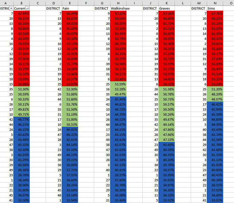
Four options for Clark County
Here are the four initial maps produced by the four members of the redistricting. You can look at each map and assess where you live and compare the current legislative districts with each of the proposed districts.
Commissioner April Sims is a Democrat appointee and works as the Secretary Treasurer of the Washington State Labor Council. The Sims map shrinks the 17th District, putting current Rep. Vicki Kraft into the 18th District, but leaving Sen. Lynda Wilson and Rep. Paul Harris in the 17th. Her map leaves Reps. Brandon Vick and Larry Hoff in the 18th District and Sen. Ann Rivers is moved into the 20th District.
Graves is an attorney and Republican appointee who served in the House representing the 5th District for one term from 2017-18. His proposal for Clark County dramatically moves the 17th District east, to include east Vancouver, Camas, Washougal, and all of Skamania County.
Under Graves, the 20th District extends from Cowlitz County down into east Vancouver and rural north and east Clark County. It extends around Battle Ground, which is part of the redrawn 18th District. The 18th includes northeast Vancouver and large parts of Clark County west of I-5 including Ridgefield. It appears to keep current 18th legislators in the district, but puts Rep. Kraft, Sen. Annette Cleveland and Rep. Monica Stonier in the 18th.
Fain is an attorney and Republican appointee who has served the 47th District as a state senator from 2011-2018. His map shrinks the 17th District, carving out a piece of southeast Vancouver for the 18th District. Harris would be moved into the 18th as is Cleveland, whereas Kraft would remain in the 17th.
Brady Piñero Walkinshaw is a businessman who served as a democratic representative for the 43rd District from 2013-2016. His map protects current 49th reps in the district, but moves Sen. Lynda Wilson into the 18th, and Harris, Vick, and Hoff into the 49th. Rivers is moved into the 20th District.
The 49th District has been solid Democrat for over a decade.
The current 17th District is viewed as “purple” from a political perspective. While it currently is represented by three Republicans, the margin of victory has been very small for the past decade.
Three of the proposals move Camas, Washougal and east Clark County into a district with Skamania County. The Skamania County population is just over 12,000 residents; 90 percent is forested land, and 80 percent is within the Gifford Pinchot National Forest.
The commission uses census data to identify districts where boundaries may need to change. The congressional districts will be adjusted to meet a new population target of 770,000 people in each of the 10 districts. The target population for state legislative districts will be 157,000.
For those citizens wanting to provide input, the Redistricting Commission website allows for you to draw your own maps and to submit comments on the existing maps proposed by the four commissioners. Go here to learn more and offer feedback.