

An EF-0 twister did cause minor damage on a farm in Northwest Portland
CLARK COUNTY — Teams with the National Weather Service in Portland confirmed an EF-0 tornado touched down on Sunday evening in Northwest Portland off of Cornelius Pass Road. EF-0 tornadoes can generate wind speeds of up 65 to 85 miles per hour. This one laid flat some corn at a farm, tore some solar panels loose, and ripped up an outside portable shelter.
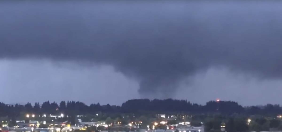
Rebecca Muessle, a meteorologist with the National Weather Service in Portland, said no teams were sent to Clark County, despite at least two funnel clouds reported over the Orchards area of Vancouver between 7:46 p.m. and 8:01 p.m. last night.
“We had the initial report on a funnel cloud and radar was showing good rotation that would be consistent with a tornado,” said Muessle, “but we did not receive any reports of an actual tornado touching the ground.”
That was in contradiction with a tornado warning issued by the Weather Service when the initial funnel cloud was spotted. Muessle says they have to use their best guess from spotters and radar data when issuing those reports.
“We try to go with our confidence,” she says, “so if we feel that we are confident enough that there’s going to be a tornado, or at least the threat of a tornado, we try to warn on it. Because, ultimately, our mission here at the National Weather Service is to protect life, and property.”
There were some people who complained that the warning didn’t arrive on their phones, despite being in the cone of the potential tornado. Muessle says it’s possible some of them were in the warning area, but their cell phone was pinging off of a tower outside of that area, though she admitted it wasn’t her area of expertise.
The storm did dump a huge amount of rain in a short time, causing temporary flooding on I-5 and I-205 in the Salmon Creek area.
*Note: below video contains adult language.
Language warning. i5 flooding. @CRESA @NWSPortland @wsdot_sw @wspd5pio pic.twitter.com/UafBRFWzh5
— SWESA (@SWESAlerts) September 9, 2019
What causes a tornado?
That’s a complicated question, says Muessle, for a complicated weather phenomenon.
“Some of the things that we look for is areas of convection,” she says. “So areas with a lot of lifts, where the air is rising really quickly.”
That explains why September and October are, historically, the most likely months for tornadoes in the Pacific Northwest. As the weather turns, a sun break can quickly heat up the ground, followed by a rapid storm front. The warm lower atmosphere lifts up the clouds, sometimes creating a vortex.
“It all comes to air circulation, and buoyancy,” says Muessle, adding that “there’s a lot of different variables that we look at. But mostly it’s pressure and convection.”
Those conditions are often present during thunderstorms, when convection in the atmosphere causes friction, leading to a build-up of static electricity, eventually released in the form of lightning bolts.
“It’s all kind of a delicate system that creates those thunderstorms,” says Muessle, “but once they’re going, they’re going.”
And we may not be out of the woods yet. Thunderstorms are in the forecast again for this evening, and Tuesday afternoon. At this point Muessle says it appears less likely a tornado could form, but they’re not ruling anything out.
“We’re not ruling anything out,” she says. “Still keeping an eye on the system very, very closely and watching all of these storms kind of move through.”
An increase in tornadoes?
One common question after the funnel clouds and minor tornado on Sunday night has been whether such weather events have become more common around the area in recent years.
“We don’t necessarily think that there’s an increase in the number of storms, but rather an increase in the amount of reporting of storms,” says Muessle. “Social media has played a huge role in that where people can easily tweet us a photo of a cloud that they’re seeing.”
That’s not necessarily a bad thing either. Muessle says they’ve seen an increase in interest for their weather spotter training courses.
“As we train people about spotting severe weather, and also taking safety precautions, we’re able to also get more reports in that way, which is definitely helpful,” she said.
On top of more in-person reports, weather forecasting equipment has gotten more powerful and higher resolution, enabling forecasters to quickly spot storms that could potentially lead to a tornado, and issue a warning.
“When we do issue any kind of a tornado warning, we don’t issue those wanting people to ignore them,” says Muessle. “We do ask that people do take heed, take shelter, and take safety precautions. We’re only showing them because we do think that there is a tornado possible.”
Tornado safety tips
If a tornado watch or warning is issued for your location, here is some of what you should do according to Ready.gov:
- If you can safely get to a sturdy building, then do so immediately.
- Go to a safe room, basement, or storm cellar.
- If you are in a building with no basement, then get to a small interior room on the lowest level.
- Stay away from windows, doors, and outside walls.
- Do not get under an overpass or bridge. You’re safer in a low, flat location.
- Watch out for flying debris that can cause injury or death.
- Use your arms to protect your head and neck.