

The new plan offers a statewide roadmap for identifying the best places to protect and restore wildlife movement, whether through safer road crossings, land conservation, or better-informed local planning
OLYMPIA — The Washington Department of Fish and Wildlife (WDFW), in partnership with the Washington State Department of Transportation (WSDOT), has released a landmark strategy to reduce wildlife-vehicle collisions, reconnect habitats fragmented by development, and help the state’s wildlife adapt to climate change.
The Washington Habitat Connectivity Action Plan (WAHCAP) offers a statewide roadmap for identifying the best places to protect and restore wildlife movement, whether through safer road crossings, land conservation, or better-informed local planning.
“Wildlife don’t stop at county lines or property fences,” said Julia Michalak, WDFW’s priority habitats and species section manager. “This plan gives Washington a common map and shared tools so that people across the state – local planners, landowners, tribal governments, state and federal agencies – can work together to reconnect the land.”
Every year in Washington, thousands of animals are hit by vehicles, causing injuries to people and costly damage to property, and killing wildlife—including threatened or endangered species. At the same time, climate change is shifting where species live and migrate. Reconnecting landscapes is one of the most effective strategies for helping wildlife survive those changes.
A statewide blueprint for wildlife movement
As the human presence on Washington’s landscape grows, roads and development make it harder for wildlife like deer, elk, cougar, and black bears to find food, migrate, and adapt to climate change. This new plan addresses these challenges through a variety of innovative resources, including:
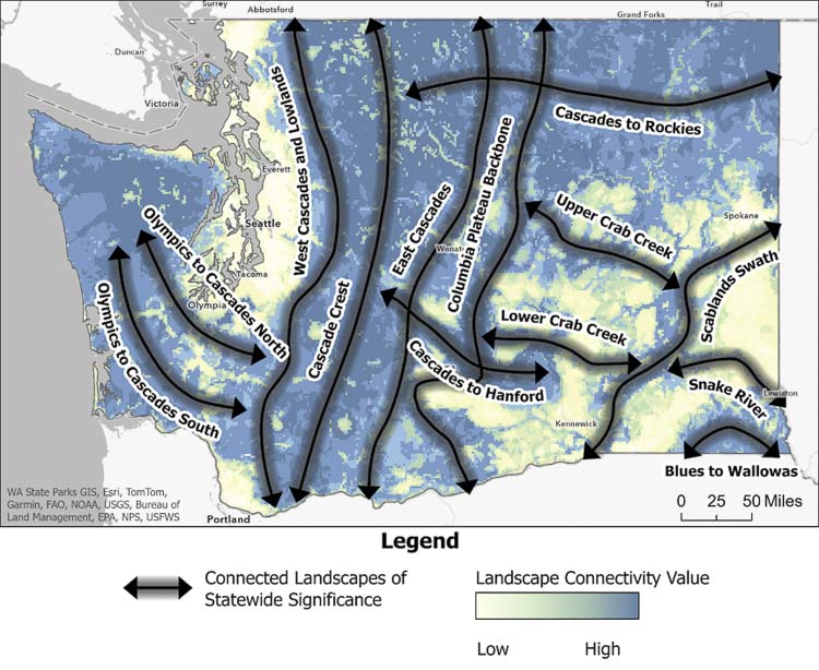
- High-priority road segments: The plan identifies 38 sections of state highways where actions like building wildlife crossings, installing fencing, or retrofitting culverts could offer the most significant benefits statewide—dramatically reducing collisions and restoring movement corridors for wildlife. The plan also breaks the entire state highway system into mile-long increments, ranking them by their potential to improve connectivity and prevent wildlife-vehicle collisions.
- Statewide wildlife pathways: The plan outlines 13 large “connected landscapes of statewide significance” that are essential for connecting major ecological core areas across the state. Protecting these broad zones is key to keeping habitats connected over the long term.
- Regional planning tools: The plan includes publicly available interactive maps that combine 10 key types of ecological data—such as climate resilience, habitat quality, and species movement needs—to help local governments, tribes, and landowners identify where and how to act.
Developed in collaboration with local and tribal governments, conservation groups, and technical experts, the plan includes regional strategies tailored to the specific needs of different parts of the state.
What’s next
WAHCAP is already informing efforts to secure federal infrastructure and climate funding for wildlife crossings and conservation. Local governments are encouraged to use WAHCAP data in land-use planning, zoning, and open space protection.
“The data in WAHCAP will help WSDOT plan safer roads that work better for people and wildlife,” said Glen Kalisz, habitat connectivity biologist at WSDOT. “This kind of statewide coordination allows us to identify where to focus our investments, design more effective crossings, and support healthy ecosystems across Washington.”
The full plan is available at the WDFW website. Interactive maps and other planning resources are available at ArcGIS online.
About WDFW
The Washington Department of Fish and Wildlife is dedicated to preserving, protecting, and perpetuating the state’s fish, wildlife, and ecosystems while providing sustainable recreational and commercial opportunities.
About WSDOT
The Washington State Department of Transportation is focused on providing safe, sustainable, reliable and cost-effective transportation options to improve livable communities and economic vitality for people and businesses.
Also read:
- Opinion: Lawsuit filed against the unconstitutional income tax in Washington state
 Former Attorney General Rob McKenna and Supreme Court Justice Phil Talmadge challenge the 9.9% income tax in Klickitat Superior Court.
 - Vancouver Police investigate domestic violence homicide
 Vancouver Police Major Crimes Unit investigating after woman found dead with knife wounds on NE Oakbrook Circle.
 - Letter: ‘Oregon and Washington aren’t refusing to clean their rolls — they’re contesting federal jurisdiction and timing’
 Camas resident challenges Lars Larson’s fraud claims, explaining legal disputes over federal jurisdiction.
 - County Council to hold hearing on preferred land use alternative for comprehensive plan update
 Clark County Council will select preferred land use alternative from three options studied in environmental review.
 - Opinion: ‘When are we going to get the full and complete details of the Interstate Bridge Replacement Program’s I-5 Bridge replacement project?’
 IBR team buried key details about light rail ending at waterfront with massive elevator system required.
 - POLL: Do you support extending light rail beyond the waterfront to connect with C-TRAN at Library Square?
 Readers can weigh in on Anne McEnerny-Ogle’s proposal to extend light rail beyond the waterfront to Library Square for improved C-TRAN connections.
 - Opinion: Passing a cyclist – Law, myth and a little patience
 Most drivers can’t legally pass cyclists in-lane due to vehicle width versus road measurements.