

Camas resident John Ley says the ‘data’ shows people want and need traffic congestion relief and improved freight mobility
Editor’s note: Opinions expressed in this column are those of the author alone and do not reflect the editorial position of ClarkCountyToday.com
John Ley
Camas
At their Nov. 18 signing ceremony, Governors Jay Inslee and Kate Brown told citizens that the Interstate 5 Bridge “must” be replaced. Inslee said there is “no other option.” Furthermore, they said the new replacement bridge and infrastructure must include high capacity transit. Both assumed part of the financing would include tolling. Finally, both Governors promised the solution would be “data-driven.”
From a KIRO news report (here):
The only condition set in the paperwork signed by both governors on Monday is that the new bridge must have high capacity transit. Gov. Inslee said that doesn’t mean light rail, but that would be his first option.
“We’re not setting pre-conditions of type of high capacity systems,” he said. “We’re going to be driven by data, it will be a very thorough analysis of the alternatives, and we’ll have a vigorous discussion in our constituencies to see what their thoughts are.”
While most commuters in southwest Washington and northwest Oregon want congestion relief, the priorities for both governors put congestion relief last on their lists.
“The number one priority has to be seismic resilience for this particular project,” Gov. Brown said. “Secondly for me it would include high capacity public transit. Hopefully that would move us toward reducing congestion.”
“Hope” doesn’t solve anyone’s traffic congestion problems, Governor.
KIRO reports an important fact.
Gov. Inslee has no idea how much it will cost to replace the bridge. It would have cost over $3 billion in 2011, but Inslee said there is no other option but to replace it.
“The first order of business is to have a bridge that is not going to fall down tomorrow,” he said.
The bridge is considered safe, but it is in need of a seismic upgrade.
As reported in Clark County Today:
“My answers would be largely the same,’’ Inslee said. “I think the reality of this is, sometimes we sort of forget the purpose of this. This bridge could fall down any day, with a small seismic event. We do not have a choice, we have to replace this bridge.”
Gov. Inslee’s hyperbole is wrong. The bridge won’t “fall down any day.” The Interstate 5 Bridge is not listed as “unsafe” by either ODOT or WSDOT. KIRO accurately reports there is no need to replace the two structures; they just need a seismic upgrade. One bridge was new in 1958; it’s only eight years older than I-5’s Marquam Bridge, which carries more vehicles than the Interstate 5 Bridge. The original bridge received a significant upgrade in 1958. Both could serve as a viable “local” connection to Hayden Island and Marine Drive, removing significant numbers of vehicles off I-5. See articles here and below.
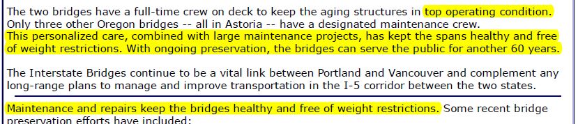
Furthermore, ODOT told the community (here) during the CRC debate that “with ongoing preservation, the bridge could serve the public for another 60 years”.
Clark County Today had the best, most revealing reporting. Ken Vance shared in a column (here) the question asked by reporter Chris Brown:
Brown asked the governors to state what the most important element of the I-5 Bridge replacement project should be? Brown offered choices of decreasing commute times (reducing congestion), adding a mass transit option, or safety.
“There’s no question for me that our absolute No. 1 priority has to be seismic resilience for this particular project,’’ Oregon Gov. Kate Brown said. “Secondly, for me, it would include high capacity public transit hopefully that would move us toward reducing congestion.’’
Washington Gov. Jay Inslee virtually repeated Gov. Brown’s answer.
What does the data say people want?
First, 94 percent of people want to use their privately owned vehicles according to the 2018 PEMCO transportation survey (viewed here).
When you are commuting to and from work or school, or out doing errands or other activities, what form of transportation do you most often use?
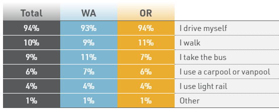
Graphic courtesy of PEMCO
Second, an April 2019 Oregon Transportation Commission survey found 51 percent of citizens want to “expand and improve interstates and interstate bridges.” Another 14 percent want expanded arterials.
Third, Metro’s 2019 poll showed people’s top priority is roads and highways. The Portland Tribune summarized: “On its own, improving public transit is a lower priority than making road improvements and the more overarching goal of easing traffic — voters still overwhelmingly rely on driving alone to get around,” reads the poll’s conclusions.
As reported by the Cascade Policy Institute (here): “More than 75 percent of residents in the Portland tri-county region commute to work by car. Therefore, it should come as no surprise that a similar percentage of voters surveyed by Metro consider traffic congestion a serious problem (73 percent) and say that improving roads, bridges, and highways to ease traffic should be a regional goal (78 percent).”
Fourth, a new study reports Portland has the seventh worst traffic congestion in the nation.
Portland took seventh in a new ranking that looked at the average drive times for people in large cities across the U.S.
The study, published by Apartment Guide, found that drivers in the Portland metro lost about 116 hours each year from congestion on the roads.It also said that the cost of congestion per driver was $1,625 a year.
The CRC traffic data
Transportation architect Kevin Peterson has designed and built transportation systems all over the world. He scrutinized all the CRC traffic projection data and reported that in 2030, the I-5 corridor would need six lanes in each direction crossing the Columbia River. Furthermore, the I-5 corridor would need 9 lanes in each direction by 2060.
Most importantly, Peterson reported those lanes are “valuable only if three to four additional lanes (are) added into downtown Portland. This is a 12-14 lane freeway passing through the Rose Quarter.”
He summarized his finding by publishing the following graphic.
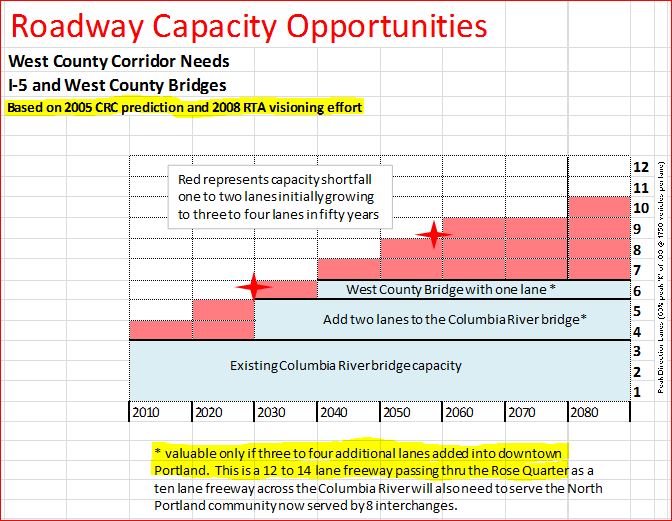
Graphic courtesy of Keven Peterson
The question for Governor’s Inslee and Brown — are you committed to building a 12-14 lane freeway through the Rose Quarter?
That is what the data shows according to transportation architect Kevin Peterson. If you’re not going to demand more through lanes at the Rose Quarter, then you’re not serious about what the data shows is needed to reduce congestion. Sadly you’d be wasting scarce transportation dollars.
Peterson: new transportation corridors are needed
Peterson reported that new east and west transportation corridors are truly what’s needed. He acknowledged Portland’s unwillingness to add that many lanes to I-5 at the Rose Quarter, but called it “the bull in the china shop”. Peterson was well aware of the data when a new transportation corridor was built.
It’s been almost 40 years since I-205 was built. opening in Dec. 1982. Regional population (and the number of cars on the road) has doubled. The new transportation corridor provided a decade of congestion relief on I-5 and the Interstate Bridge.
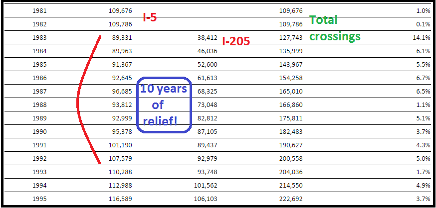
Graphic courtesy of John Ley ( from RTC data)
If politicians had followed through and built a western bypass corridor (planned to open in 1990), the I-5 corridor would have enjoyed even longer congestion relief. (Map here.)
Washington County would not be “gridlocked” today, as Commissioner Roy Rogers told the tolling PAC in 2018. Former Oregon Rep. Rich Vial would not have had to propose his “northern connector” in 2017 (here). The people told the Washington County Commission (here):
For a new route linking the Sunset Highway near Hillsboro to I-5, 68 percent of those sampled strongly or somewhat favored it; 23 percent opposed it.
For a new route linking the Sunset Highway to U.S. 30, 60 percent strongly or somewhat favor it; 24 percent opposed it.
Peterson also estimated an east county bridge (east of I-205), would provide 15-20 percent relief to the I-205/I-84 interchange from Airport Way south. See his July 2014 presentation to our community here.
The Seismic Issue
Both Governors said their top priority was “safety” due to alleged seismic concerns. But neither ODOT nor WSDOT say the two interstate bridges are “unsafe.” As KIRO reported: “The bridge is considered safe, but it is in need of a seismic upgrade.“
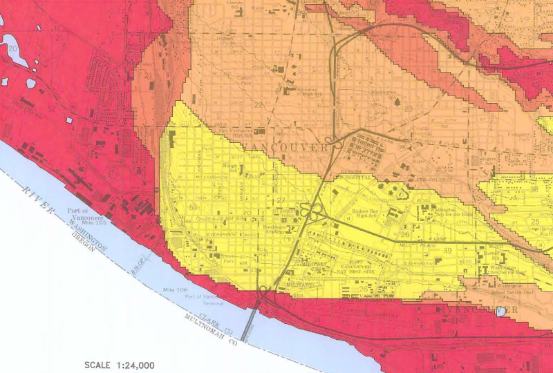
The Interstate 5 Bridge is not the “oldest” bridge in the region. In fact, every light rail train line crosses the Willamette River on the Steel Bridge, built in 1912.
What are the seismic hazards?
Both Governors allege concern over the Cascadia Subduction Zone and its potential for a 9.0 earthquake. The Oregon Department of Geology (DOGAMI) issued a report in 2018. They shared:
“Earthquakes come from four different sources: crustal, subduction zone, intraplate, and volcanoes. The most common are crustal earthquakes, which occur along faults, or breaks in the earth’s crust, at shallow depths of 6-12 miles (10-20 km) below the surface. The two largest earthquakes in recent years in Oregon, Scotts Mills (magnitude 5.6) and the Klamath Falls main shocks (magnitude 5.9 and magnitude 6.0) of 1993 were crustal earthquakes.
“Great subduction zone earthquakes occur around the world where the tectonic plates that make up the surface of the earth collide. When these plates collide, one plate slides (subducts) beneath the other, where it is reabsorbed into the mantle of the earth. This sloping boundary between the two plates is the site of some of the most powerful earthquakes ever recorded, often having magnitudes of 8 to 9 or larger.’’
More specifically, we’re 320 years into a 190-1200 year Cascadia risk cycle according to DOGAMI (here).
The Cascadia Subduction Zone is a 600-mile fault that runs from northern California up to British Columbia and is about 70-100 miles off the Pacific coast shoreline. There have been 41 earthquakes in the last 10,000 years within this fault that have occurred as few as 190 years or as much as 1,200 years apart. The last earthquake that occurred in this fault was on Jan. 26, 1700, with an estimated 9.0 magnitude.
Their data shows the entire I-5 corridor from the Oregon border to south of Tualatin are “at risk” in a Cascadia Subduction Zone earthquake. That means to solve potential seismic problems, the Marquam Bridge, the Fremont Bridge, the Rose Quarter for both I-84 & I-5 and all the dozen bridges crossing the Willamette River must be replaced or significantly upgraded. I-205 needs upgrades as well at both the Glenn Jackson Bridge and Abernethy Bridge.
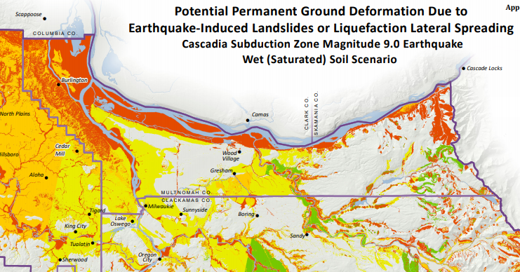
Here’s a graphic DOGAMI created showing “at risk” transportation networks. Dark red and maroon highways have the highest risk.
Graphic taken from DOGAMI (Oregon Dept. of Geology)
You’ll note I-5 is worse than I-205, but both are at risk in a 9.0 magnitude earthquake. The red is 1-2 meters of ground movement, and the darker brown is greater than 2 meters (6 feet) of ground movement. There are no highways in the region that don’t “move” at least 3 feet — can you say unusable.
But if you look at the regional map below, the area of Wood Village and north Gresham have minimal “risk” according to DOGAMI.
Why not build a new, 3rd bridge across the Columbia River in an area that has reduced risk, in east Clark County and Multnomah County? If the governors are truly concerned about seismic risk then building in an area with significantly reduced seismic risk is logical.
Graphic courtesy of DOGAMI
And “yes” the area around downtown Vancouver is also “at risk”. A western bypass would be “best” if built crossing from Woodland to St. Helens or Scappoose.
Graphic courtesy of WA Dept. of Natural Resources
Another light rail project in search of a bridge?
In the previous battle over the Columbia River Crossing (CRC), an Oregon Supreme Court Justice correctly labeled the project “a light rail project in search of a bridge.” Read “A Bridge Too False” here. As Willamette Week reported:
A 2010 governors’ independent review panel found the massive project will shave exactly 60 seconds off the peak morning commute.
And here’s why: The Interstate 5 Bridge and nearby interchanges are just one bottleneck. The project does nothing to fix the choke point at the Rose Quarter, five miles south, where I-5 narrows to two lanes.
Today, the bridge actually serves as a traffic-control device by slowing the flow of cars headed toward the Rose Quarter. A wider bridge with streamlined interchanges will simply create a bigger jam down the road.
Last summer, the governors’ review panel said that failing to address the Rose Quarter congestion would be like hooking a garden hose to a fire hydrant.
“Questions about the reasonableness of investment in the CRC bridge because of unresolved issues to the south [the Rose Quarter] threaten the viability of the project,” the panel wrote in July 2010.
The 2010 Oregon Governor’s panel found the Rose Quarter must be addressed. More importantly, government bodies have repeatedly found there was a need for more bridges across the Columbia River.
The 2008 RTC “Visioning Study” identified the need for two new transportation corridors across the Columbia River, one west of I-5 and one east of I-205.
In a 2003 Portland/Vancouver I-5 Transportation & Trade Partnership, ODOT Director Bruce Warner offered the following comparison of river crossings.
Portland had two highway crossings and one rail crossing.
Norfolk had four highway crossings and zero rail crossings. Cincinnati had seven highway crossings and two rail crossings. Kansas City had 10 highway crossings and three rail crossings. Pittsburgh had over 30 highway crossings and three rail crossings. St. Louis had eight highway crossings and two rail crossings.
By any measure, the Portland metro area was behind 16 years ago. We’re further behind today.
In 1977-79, a Washington legislature study found: “Without a new crossing, the I-5 bridge would be overloaded 30 percent beyond its capacity by the year 2000.” Their report included five possible locations for a third bridge.
A 1980 Washington legislature study concluded: “travel demand on the I-5 corridor beyond the year 2005 will require additional facilities.”
A 1980 Oregon & Washington Governor’s Task Force said “a 3rd bridge would not increase the capacity for interstate travel unless it were accompanied by a new corridor north and south of the Columbia River.” The technical analysis concluded that “the region would not have to revisit the question of additional river crossings until 1990.”
Additionally, that same study recommended “bottlenecks north and south of the I-5 bridge were the limiting factors and not the bridge itself.”
The 1980 Bi-State Study forecast 185,000 cross-river daily vehicle trips in 2000.
A 1988 study show I-205 traffic had already exceeded the 2000 forecast. Today, WSDOT reports roughly 310,000 daily crossings. That 1988 study also discussed the benefits of two new bridge crossings, one west of I-5 and one east of I-205.
That’s seven government studies since I-205 construction began that data showed the need for more bridges and transportation corridors across the Columbia River. Understand that Oregon’s current plans for the Rose Quarter will not add any new through lanes.
Mass transit won’t solve the problem
At present, only 1,422 Southwest Washington citizens ride any of the seven C-TRAN Express bus lines into Portland on an average day. Five travel the I-5 corridor and two travel the I-205 corridor. This is about 203 people per express bus line daily. That’s a rounding error of the 310,000 vehicles WSDOT reports cross the Columbia River daily.
Furthermore, mass transit use is down from its peak nearly a decade ago in the region. TriMet’s MAX light rail ridership is down in spite of adding two new light rail lines in the past 10 years. The MAX Yellow line travels at an average speed of about 15 mph, with 17 stops from the Expo Center to PSU.
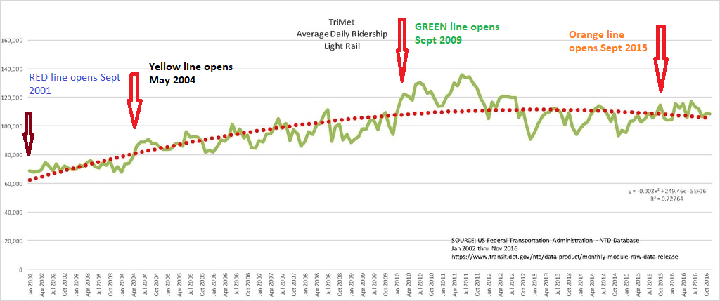
Graphic courtesy of US Federal Transportation Administration
TriMet bus ridership is down 14 percent, or 9.4 million annual passenger boards according to their annual report. And while C-TRAN has recently reported a slight increase in bus ridership, it is still 1.25 million passenger boardings below the 1999 peak ridership, an 18 percent decline.
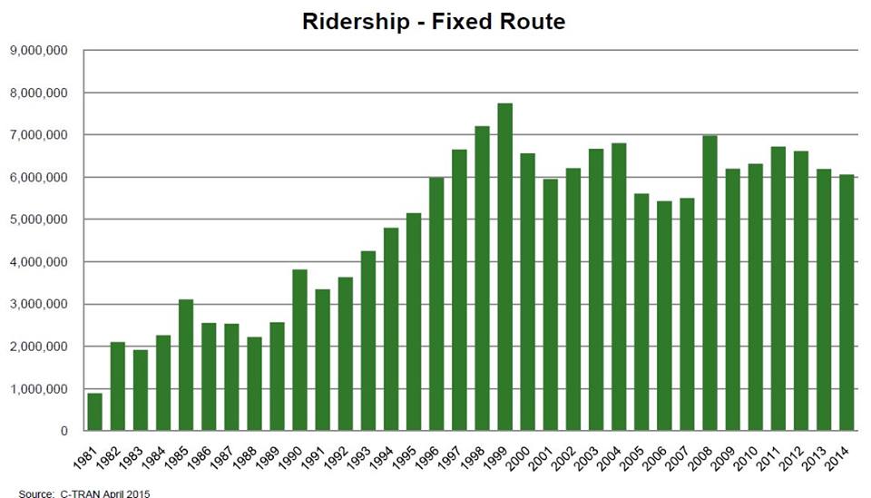
Graphic courtesy of C-TRAN Annual Report
Clearly, the “data driven” past studies indicate the region needs more than two bridges and transportation corridors across the Columbia River. Clearly, the data shows the entire I-5 corridor including the Marquam Bridge, the Rose Quarter, the Fremont Bridge and much more of the region’s highways are “at risk” in a Cascadia Subduction Zone event. The data shows an east county bridge connecting in Gresham or near Wood Village would have the least seismic risk. The data shows we are only 320 years into a 1,200 year “risk” time frame.
Both governors push mass transit, but that won’t solve the traffic congestion problems. Declining numbers of people ride it. It doesn’t go where they want, and it goes too slow. Furthermore, with all MAX light rail trains crossing the 1912 Steel Bridge, a seismic failure would also shut down much of the MAX system. Only new road and bridge capacity will reduce traffic congestion.
We should spend scarce transportation resources to add new bridges and transportation corridors. That is what the people want. As PEMCO showed, 94 percent of people prefer to use their cars. Why not keep the Interstate 5 Bridge? ODOT said it was “safe” and could serve the people for 60 years. Build a new, third bridge connecting Oregon and Washington.
Just the “facts” and data driven solutions.