

The new plan offers a statewide roadmap for identifying the best places to protect and restore wildlife movement, whether through safer road crossings, land conservation, or better-informed local planning
OLYMPIA — The Washington Department of Fish and Wildlife (WDFW), in partnership with the Washington State Department of Transportation (WSDOT), has released a landmark strategy to reduce wildlife-vehicle collisions, reconnect habitats fragmented by development, and help the state’s wildlife adapt to climate change.
The Washington Habitat Connectivity Action Plan (WAHCAP) offers a statewide roadmap for identifying the best places to protect and restore wildlife movement, whether through safer road crossings, land conservation, or better-informed local planning.
“Wildlife don’t stop at county lines or property fences,” said Julia Michalak, WDFW’s priority habitats and species section manager. “This plan gives Washington a common map and shared tools so that people across the state – local planners, landowners, tribal governments, state and federal agencies – can work together to reconnect the land.”
Every year in Washington, thousands of animals are hit by vehicles, causing injuries to people and costly damage to property, and killing wildlife—including threatened or endangered species. At the same time, climate change is shifting where species live and migrate. Reconnecting landscapes is one of the most effective strategies for helping wildlife survive those changes.
A statewide blueprint for wildlife movement
As the human presence on Washington’s landscape grows, roads and development make it harder for wildlife like deer, elk, cougar, and black bears to find food, migrate, and adapt to climate change. This new plan addresses these challenges through a variety of innovative resources, including:
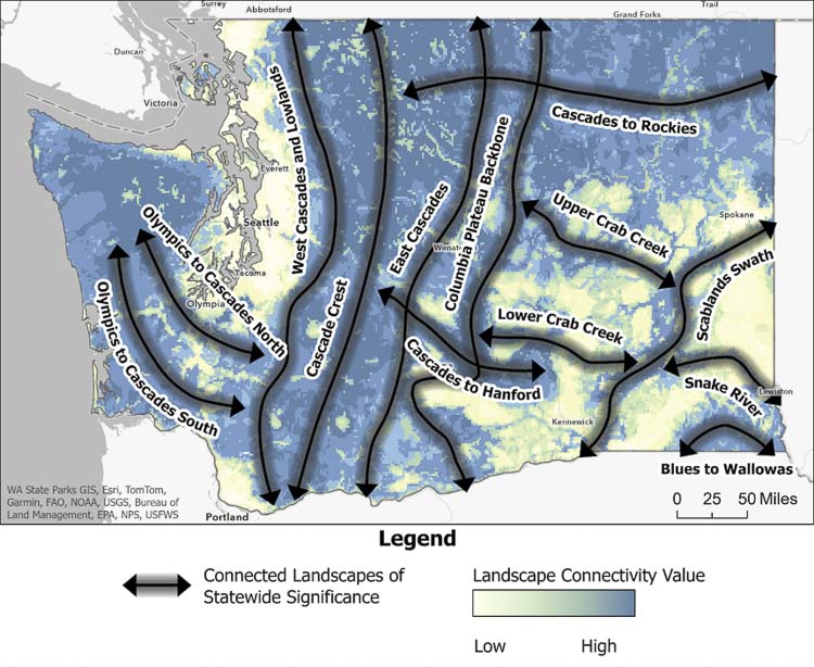
- High-priority road segments: The plan identifies 38 sections of state highways where actions like building wildlife crossings, installing fencing, or retrofitting culverts could offer the most significant benefits statewide—dramatically reducing collisions and restoring movement corridors for wildlife. The plan also breaks the entire state highway system into mile-long increments, ranking them by their potential to improve connectivity and prevent wildlife-vehicle collisions.
- Statewide wildlife pathways: The plan outlines 13 large “connected landscapes of statewide significance” that are essential for connecting major ecological core areas across the state. Protecting these broad zones is key to keeping habitats connected over the long term.
- Regional planning tools: The plan includes publicly available interactive maps that combine 10 key types of ecological data—such as climate resilience, habitat quality, and species movement needs—to help local governments, tribes, and landowners identify where and how to act.
Developed in collaboration with local and tribal governments, conservation groups, and technical experts, the plan includes regional strategies tailored to the specific needs of different parts of the state.
What’s next
WAHCAP is already informing efforts to secure federal infrastructure and climate funding for wildlife crossings and conservation. Local governments are encouraged to use WAHCAP data in land-use planning, zoning, and open space protection.
“The data in WAHCAP will help WSDOT plan safer roads that work better for people and wildlife,” said Glen Kalisz, habitat connectivity biologist at WSDOT. “This kind of statewide coordination allows us to identify where to focus our investments, design more effective crossings, and support healthy ecosystems across Washington.”
The full plan is available at the WDFW website. Interactive maps and other planning resources are available at ArcGIS online.
About WDFW
The Washington Department of Fish and Wildlife is dedicated to preserving, protecting, and perpetuating the state’s fish, wildlife, and ecosystems while providing sustainable recreational and commercial opportunities.
About WSDOT
The Washington State Department of Transportation is focused on providing safe, sustainable, reliable and cost-effective transportation options to improve livable communities and economic vitality for people and businesses.
Also read:
- POLL: Did the Clark County Council make the right decision by rejecting the auditor authority proposal?
 The 3-2 council vote rejected giving the auditor’s office power to write financial impact statements for ballot measures.
 - Low sockeye salmon returns lead to fishery changes in the Columbia River
 WDFW projects sockeye returns to Bonneville Dam at less than half the pre-season forecast of 275,000 fish.
 - WA employers added jobs in May, but unemployment rate stayed stuck at 5.2%
 Washington added 10,600 jobs in May — its best month this year — yet unemployment held at 5.2%, up from 4.5% a year ago.
 - Opinion: Hospital price transparency is good, but its impact will be limited
 Washington still shields hospitals from competition through certificate-of-need laws other states have repealed.
 - Evergreen Public Schools and Teachers Union agree to a five-year contract
 Evergreen Public Schools reached a five-year deal with its teachers union, covering 22,000 students across 38 Vancouver schools.
 - Vancouver amends municipal code, banning pedestrians from staying on traffic islands, medians
 Vancouver’s new ordinance targets people who remain on medians, not those crossing legally at crosswalks.
 - Tri-County SAR Teams conduct joint training exercise to enhance emergency response readiness
 Six Southwest Washington SAR teams trained together in a simulated aircraft crash requiring day and nighttime rescue operations.