

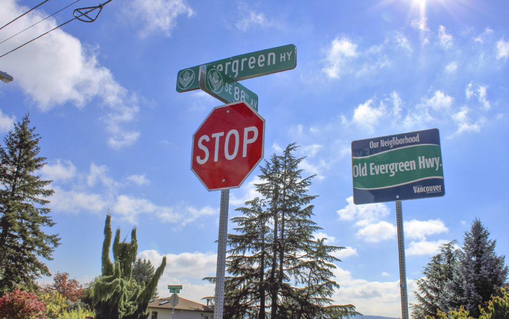
Vancouver – With shared-use trails in the works and repaving projects underway on Vancouver’s historic Evergreen Highway, city councilors are looking at ways to improve the roadway and make the historic seven-mile stretch, which parallels the Columbia River between east Vancouver and Camas, safe for everyone.
But keeping things safe means reduced speed limits and getting morning commuters to stop using the two-lane roadway as a shortcut, says Vancouver Senior Planner Jennifer Campos.
“There are a significant number of people using (the historic highway) as a bypass,” Campos told the Vancouver City Council during a recent workshop on the Evergreen Corridor Project, which is forming a long-term strategy to improve the Southeast Evergreen Highway and turn it into a shared-use roadway that is safe for drivers, bicyclists and pedestrians. “We are seeing more traffic in the corridor and higher speeds.”
According to Campos, as State Route 14 (SR-14), which also connects Vancouver and Camas, sees more traffic congestion, particularly during the morning commute, many drivers are using Southeast Evergreen Highway to bypass standstill traffic on the “real” highway.
Weekday mornings, between 7 a.m. and 8 a.m., see an additional 200 to 600 westbound cars on the nearly 100-year-old, two-lane highway, stressing the road’s already failing pavement and risking the lives of neighborhood residents who want to use the road for walking or biking.
“Bypass traffic is increasingly getting worse due to increasing congestion on SR-14,” Campos says.
What’s more, since the city has started repaving portions of the roadway – smoothing out the historic highway’s many bumps and cracks – drivers are picking up speed and making things even more unsafe for pedestrians and bicyclists.
Campos told the city councilors that the highway has posted speed limits of 25 miles per hour to 40 miles per hour, depending on the area. However, most drivers – about 85 percent – are traveling the highway at speeds between 39 and 45 miles per hour.
Those speeds are above federal recommendations for shared-use roads, Campos says.
“We want to focus on how to improve and enhance safety for people driving, biking and walking along the corridor,” she told councilors at their Oct. 3 workshop.
Federal guidelines suggest shared-use roads – those that include drivers, bicyclists and pedestrians – have speed limits no higher than 35 miles per hour, but Campos says the National Association of City Transportation Officials suggests that shared-use roads have speed limits no higher than 25 miles per hour.
“Currently, we see westbound speeds at 41 to 45 miles per hour and eastbound speeds at 39 to 44 miles per hour,” Campos told the councilors. “Speeds can stay relatively high through this free-flowing corridor.”
Citing national transportation safety statistics, Campos said increased speeds are linked to increased risks of death for pedestrians and bicyclists: a person who is hit by a car traveling 30 miles per hour, statistically, has a 45 percent chance of being killed and only a 5 percent chance of not sustaining some type of injury. When the car is traveling just 10 miles per hour faster, at 40 miles per hour, that person’s risk of dying increases to 95 percent.
“As you drive faster, your peripheral vision really narrows,” Campos told councilors, showing slides that depicted a driver’s narrowing field of vision with increasing speeds. “As you get higher than 40 miles per hour, you start to miss those people who might be walking or riding a bike on the road, or even other cars that might be pulling out onto the roadway. You have a longer stopping and reaction time as well.”
With its spectacular glimpses of the Columbia River, a history rooted in Vancouver’s earliest industrial days, and a pathway that connects residential neighborhoods from east Vancouver to Camas, the Evergreen Highway is more than just a road for many of the 1,700 residents who live nearby.
In March, several members of the Old Evergreen Highway Neighborhood Association approached the city council with requests to resurface the road and get rid of the potholes, cracks and bumps that make driving – much less bicycling – a challenge.
“I made the stubborn mistake of riding the old Evergreen Highway one time,” City Councilor Ty Stober told Campos and other Vancouver councilors. “If you have a mountain bike, you can ride that road, but if you’re on a road bike, you cannot.”
City planners expect to “lay out a strategy to resurface the roadway and do repairs – instead of reconstructing the roadway – over the next five to six years,” Campos said, adding that the city’s “intent is for something to occur every year.”
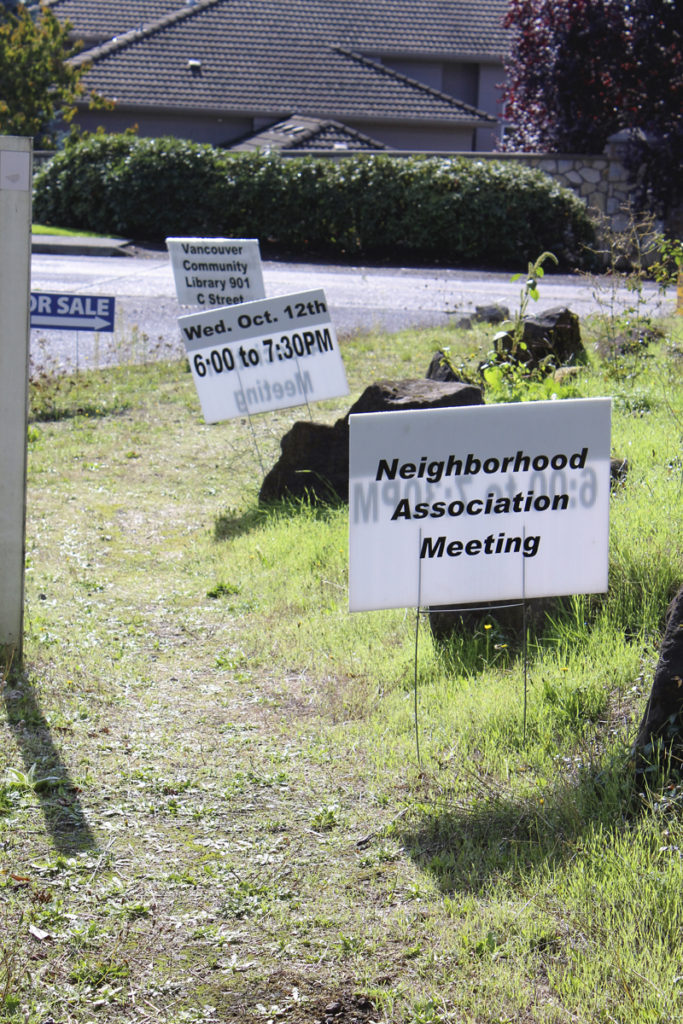
Other projects, such as a pedestrian trail, some sort of markers to commemorate the 1920 highway’s history and pedestrian benches are also in the works, and neighbors are meeting this week to discuss the future of the pedestrian trail. Campos said the city is looking at traffic-calming measures that could discourage commuters from using the road as a morning shortcut, and that they would like to lower the speed limits to improve safety for drivers, bicyclists and pedestrians.
City councilors asked Campos why the city can’t just lower the speed limits and start to calm the speeds, but Campos said it’s not considered safe to lower speed limits until the city can have something in place – police monitoring, speed cameras, etc. – to let people know that the speed limits have changed.
Vancouver Mayor Jack Burkman said, unless police were there to monitor speeding drivers, he would expect people to maintain the speeds they’re used to on the historic highway, even after the speed limits were lowered and new signs posted.
The Vancouver City Council is expected to approve a first reading of the Evergreen Corridor Management Strategy at its 6:30 p.m. council meeting tonight, Mon., Oct. 10. After that, the Old Evergreen Highway Neighborhood Association will meet to discuss the proposals at 6 p.m., Wed., Oct. 12, at the Vancouver Community Library, 901 C St., Vancouver. The city council is then expected to hold a public hearing on the Evergreen Corridor Management Strategy at its Mon., Oct. 17 city council meeting.
